Neusiedl an der Zaya elevation
Neusiedl an der Zaya (Lower Austria, Politischer Bezirk Gänserndorf), Austria elevation is 181 meters and Neusiedl an der Zaya elevation in feet is 594 ft above sea level [src 1]. Neusiedl an der Zaya is a seat of a third-order administrative division (feature code) with elevation that is 328 meters (1076 ft) smaller than average city elevation in Austria.
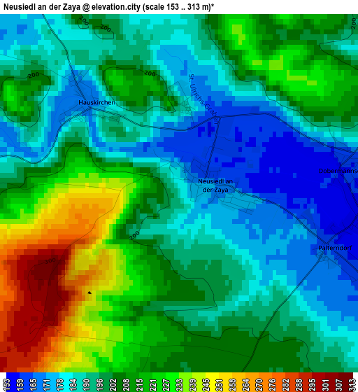
Below is the Elevation map of Neusiedl an der Zaya, which displays elevation range with different colors. Scale of the first map is from 153 to 313 m (502 to 1027 ft) with average elevation of 202.6 meters (=665 ft) [note 1]
These maps also provides idea of topography and contour of this city, they are displayed at different zoom levels. More info about maps, scale and edge coordinates you can find below images.
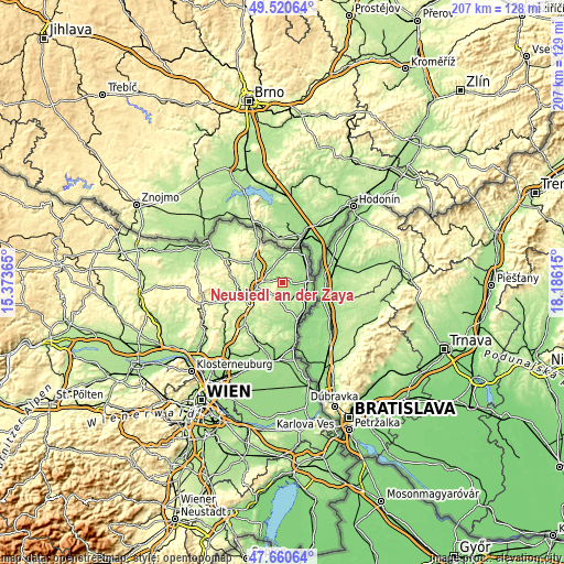
| \ | Map #1 | Topo.Map |
| Scale [m] | 153..313 m | × |
| Scale [ft] | 502..1027 ft | × |
| Average | 202.6 m = 665 ft | × |
| Width | 6.46 km = 4 mi | 206.8 km = 128.5 mi |
| Height | 6.46 km = 4 mi | 206.8 km = 128.5 mi |
| ↑Max Latitude | 48.628254° | 49.52064° |
| Latitude at center | 48.5992° | 48.5992° |
| ↓Min Latitude | 48.57013° | 47.66064° |
| ← Min Longitude | 16.735955° | 15.37365° |
| Longitude center | 16.7799° | 16.7799° |
| →Max Longitude | 16.823845° | 18.18615° |
Nearby cities:
Cities around Neusiedl an der Zaya sort by population:
• Zistersdorf elevation 188 m
6.4 km,  192°
192°
• Hohenau 152 m
9.2 km,  86°
86°
• Wilfersdorf 206 m
10.9 km,  260°
260°
• Rabensburg 167 m
10.5 km,  57°
57°
• Herrnbaumgarten 206 m
12.9 km,  326°
326°
• Großkrut 179 m
6.5 km,  320°
320°
• Drösing 158 m
11.2 km,  126°
126°
• Hausbrunn 183 m
4.7 km,  50°
50°
• Bernhardsthal 167 m
12.2 km,  32°
32°
• Altlichtenwarth 217 m
5.2 km,  13°
13°
• Jedenspeigen 156 m
13.1 km,  148°
148°
• Hauskirchen 238 m
1 km,  275°
275°
Multilingual:
 En español:
Neusiedl an der Zaya elevación 181 m.
 En France:
Neusiedl an der Zaya élévation 181 m.
 Auf Deutsch:
Neusiedl an der Zaya höhe über dem Meeresspiegel ist 181 m.
 На русском:
Нойзидль-ан-дер-Цайя высота над уровнем моря 181 м
Sources and notes:
- [note 1] Map square and city borders are not equal. Map elevation data is calculated only from area inside that square.
- [src 1] Elevation data from geonames database provided with same terms of usage.
- [src 2] The elevation map of Neusiedl an der Zaya is generated using elevation data from NASA's 3 arcsec (90m) resolution SRTM data.
- [src 3] Base (background) map © OpenStreetMap contributors tiles are generated by Geofabrik and OpenTopoMap.
Copyright & License:
This Neusiedl an der Zaya Elevation Map is licensed under CC BY-SA. You may reuse any part from this page, if you give a proper credit by linking to this URL:
 More info on terms of use page.