Ehrenhausen elevation
Ehrenhausen (Styria, Politischer Bezirk Leibnitz), Austria elevation is 269 meters and Ehrenhausen elevation in feet is 883 ft above sea level [src 1]. Ehrenhausen is a seat of a third-order administrative division (feature code) with elevation that is 240 meters (787 ft) smaller than average city elevation in Austria.
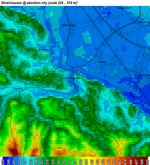
Below is the Elevation map of Ehrenhausen, which displays elevation range with different colors. Scale of the first map is from 229 to 519 m (751 to 1703 ft) with average elevation of 300.2 meters (=985 ft) [note 1]
These maps also provides idea of topography and contour of this city, they are displayed at different zoom levels. More info about maps, scale and edge coordinates you can find below images.
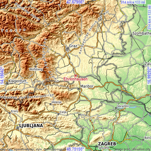
| \ | Map #1 | Topo.Map |
| Scale [m] | 229..519 m | × |
| Scale [ft] | 751..1703 ft | × |
| Average | 300.2 m = 985 ft | × |
| Width | 6.7 km = 4.2 mi | 214.4 km = 133.2 mi |
| Height | 6.7 km = 4.2 mi | 214.4 km = 133.2 mi |
| ↑Max Latitude | 46.754287° | 47.67956° |
| Latitude at center | 46.72417° | 46.72417° |
| ↓Min Latitude | 46.694037° | 45.75155° |
| ← Min Longitude | 15.542725° | 14.18042° |
| Longitude center | 15.58667° | 15.58667° |
| →Max Longitude | 15.630615° | 16.99292° |
Nearby cities:
Cities around Ehrenhausen sort by population:
• Leitring elevation 264 m
5 km,  342°
342°
• Wagna 263 m
5.2 km, 336°
• Gamlitz 279 m
2.6 km,  260°
260°
• Straß in Steiermark 255 m
2.9 km,  83°
83°
• Vogau 252 m
1.9 km,  62°
62°
• Obervogau 260 m
2.3 km,  356°
356°
• Spielfeld 258 m
4.4 km,  118°
118°
• Sankt Veit am Vogau 267 m
4.6 km,  66°
66°
• Retznei 300 m
1.8 km,  303°
303°
• Gabersdorf 271 m
5.9 km, 358°
• Ratsch an der Weinstraße 349 m
4 km,  197°
197°
• Sulztal an der Weinstraße 452 m
5.3 km,  211°
211°
Multilingual:
 En español:
Ehrenhausen elevación 269 m.
 En France:
Ehrenhausen élévation 269 m.
 Auf Deutsch:
Ehrenhausen höhe über dem Meeresspiegel ist 269 m.

Sources and notes:
- [note 1] Map square and city borders are not equal. Map elevation data is calculated only from area inside that square.
- [src 1] Elevation data from geonames database provided with same terms of usage.
- [src 2] The elevation map of Ehrenhausen is generated using elevation data from NASA's 3 arcsec (90m) resolution SRTM data.
- [src 3] Base (background) map © OpenStreetMap contributors tiles are generated by Geofabrik and OpenTopoMap.
Copyright & License:
This Ehrenhausen Elevation Map is licensed under CC BY-SA. You may reuse any part from this page, if you give a proper credit by linking to this URL:
 More info on terms of use page.