Leitring elevation
Leitring (Styria, Politischer Bezirk Leibnitz), Austria elevation is 264 meters and Leitring elevation in feet is 866 ft above sea level [src 1]. Leitring is a populated place (feature code) with elevation that is 245 meters (804 ft) smaller than average city elevation in Austria.
Below is the Elevation map of Leitring, which displays elevation range with different colors. Scale of the first map is from 243 to 384 m (797 to 1260 ft) with average elevation of 279.3 meters (=916 ft) [note 1]
These maps also provides idea of topography and contour of this city, they are displayed at different zoom levels. More info about maps, scale and edge coordinates you can find below images.
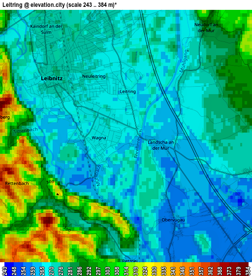
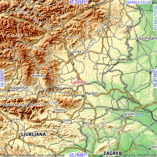
| \ | Map #1 | Topo.Map |
| Scale [m] | 243..384 m | × |
| Scale [ft] | 797..1260 ft | × |
| Average | 279.3 m = 916 ft | × |
| Width | 6.69 km = 4.2 mi | 214.2 km = 133.1 mi |
| Height | 6.69 km = 4.2 mi | 214.2 km = 133.1 mi |
| ↑Max Latitude | 46.796763° | 47.72131° |
| Latitude at center | 46.76667° | 46.76667° |
| ↓Min Latitude | 46.73656° | 45.79481° |
| ← Min Longitude | 15.522725° | 14.16042° |
| Longitude center | 15.56667° | 15.56667° |
| →Max Longitude | 15.610615° | 16.97292° |
Nearby cities:
Cities around Leitring sort by population:
• Leibnitz elevation 273 m
2.7 km,  307°
307°
• Kaindorf an der Sulm 275 m
3.6 km,  323°
323°
• Gralla 278 m
5.3 km,  350°
350°
• Wagna 263 m
0.6 km,  271°
271°
• Gamlitz 279 m
5.3 km,  191°
191°
• Vogau 252 m
5 km,  140°
140°
• Ehrenhausen 269 m
5 km,  162°
162°
• Heimschuh 276 m
5.7 km,  262°
262°
• Obervogau 260 m
2.8 km,  150°
150°
• Seggauberg 324 m
3.8 km, 270°
• Retznei 300 m
3.7 km,  180°
180°
• Gabersdorf 271 m
1.8 km,  48°
48°
Multilingual:
 En español:
Leitring elevación 264 m.
 En France:
Leitring élévation 264 m.
 Auf Deutsch:
Leitring höhe über dem Meeresspiegel ist 264 m.

Sources and notes:
- [note 1] Map square and city borders are not equal. Map elevation data is calculated only from area inside that square.
- [src 1] Elevation data from geonames database provided with same terms of usage.
- [src 2] The elevation map of Leitring is generated using elevation data from NASA's 3 arcsec (90m) resolution SRTM data.
- [src 3] Base (background) map © OpenStreetMap contributors tiles are generated by Geofabrik and OpenTopoMap.
Copyright & License:
This Leitring Elevation Map is licensed under CC BY-SA. You may reuse any part from this page, if you give a proper credit by linking to this URL:
 More info on terms of use page.