Frankenburg elevation
Frankenburg (Upper Austria, Politischer Bezirk Vöcklabruck), Austria elevation is 515 meters and Frankenburg elevation in feet is 1690 ft above sea level [src 1]. Frankenburg is a seat of a third-order administrative division (feature code) with elevation that is 6 meters (20 ft) bigger than average city elevation in Austria.
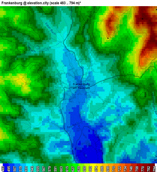
Below is the Elevation map of Frankenburg, which displays elevation range with different colors. Scale of the first map is from 483 to 794 m (1585 to 2605 ft) with average elevation of 578.3 meters (=1897 ft) [note 1]
These maps also provides idea of topography and contour of this city, they are displayed at different zoom levels. More info about maps, scale and edge coordinates you can find below images.
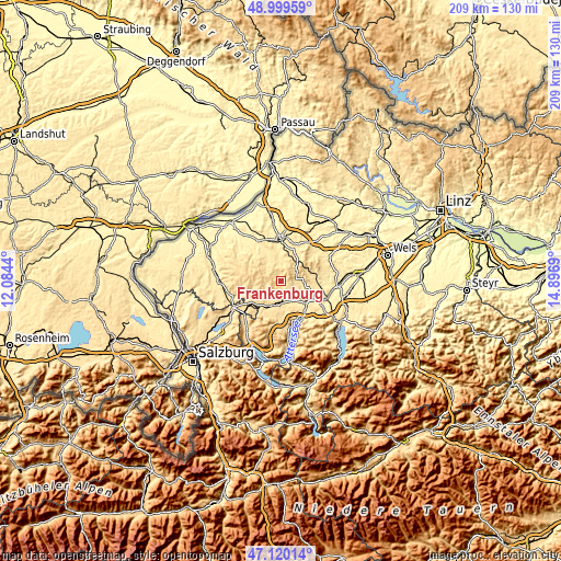
| \ | Map #1 | Topo.Map |
| Scale [m] | 483..794 m | × |
| Scale [ft] | 1585..2605 ft | × |
| Average | 578.3 m = 1897 ft | × |
| Width | 6.53 km = 4.1 mi | 209 km = 129.9 mi |
| Height | 6.53 km = 4.1 mi | 209 km = 129.9 mi |
| ↑Max Latitude | 48.097798° | 48.99959° |
| Latitude at center | 48.06844° | 48.06844° |
| ↓Min Latitude | 48.039065° | 47.12014° |
| ← Min Longitude | 13.446705° | 12.0844° |
| Longitude center | 13.49065° | 13.49065° |
| →Max Longitude | 13.534595° | 14.8969° |
Nearby cities:
Cities around Frankenburg sort by population:
• Vöcklamarkt elevation 488 m
7.3 km,  183°
183°
• Ampflwang 540 m
5.9 km,  73°
73°
• Puchlkirchen am Trattberg 553 m
6.6 km,  113°
113°
• Waldzell 511 m
8.8 km,  327°
327°
• Schildorn 524 m
8.8 km,  346°
346°
• Pramet 508 m
8.3 km,  358°
358°
• Neukirchen an der Vöckla 515 m
4.7 km,  131°
131°
• Redleiten 554 m
2.2 km,  311°
311°
• Fornach 562 m
6.8 km,  221°
221°
• Ungenach 488 m
9.5 km,  104°
104°
• Zell am Pettenfirst 568 m
8.2 km,  80°
80°
• Pfaffing 539 m
5.7 km,  191°
191°
Multilingual:
 En español:
Frankenburg elevación 515 m.
 En France:
Frankenburg élévation 515 m.
 Auf Deutsch:
Frankenburg höhe über dem Meeresspiegel ist 515 m.

Sources and notes:
- [note 1] Map square and city borders are not equal. Map elevation data is calculated only from area inside that square.
- [src 1] Elevation data from geonames database provided with same terms of usage.
- [src 2] The elevation map of Frankenburg is generated using elevation data from NASA's 3 arcsec (90m) resolution SRTM data.
- [src 3] Base (background) map © OpenStreetMap contributors tiles are generated by Geofabrik and OpenTopoMap.
Copyright & License:
This Frankenburg Elevation Map is licensed under CC BY-SA. You may reuse any part from this page, if you give a proper credit by linking to this URL:
 More info on terms of use page.