Ungenach elevation
Ungenach (Upper Austria, Politischer Bezirk Vöcklabruck), Austria elevation is 488 meters and Ungenach elevation in feet is 1601 ft above sea level [src 1]. Ungenach is a seat of a third-order administrative division (feature code) with elevation that is 21 meters (69 ft) smaller than average city elevation in Austria.
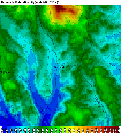
Below is the Elevation map of Ungenach, which displays elevation range with different colors. Scale of the first map is from 447 to 713 m (1467 to 2339 ft) with average elevation of 521.3 meters (=1710 ft) [note 1]
These maps also provides idea of topography and contour of this city, they are displayed at different zoom levels. More info about maps, scale and edge coordinates you can find below images.
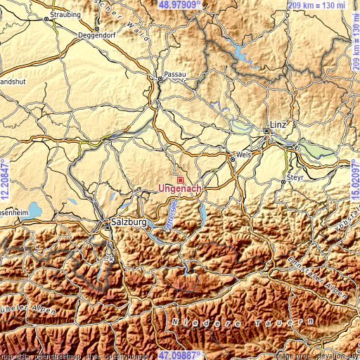
| \ | Map #1 | Topo.Map |
| Scale [m] | 447..713 m | × |
| Scale [ft] | 1467..2339 ft | × |
| Average | 521.3 m = 1710 ft | × |
| Width | 6.53 km = 4.1 mi | 209.1 km = 129.9 mi |
| Height | 6.53 km = 4.1 mi | 209 km = 129.9 mi |
| ↑Max Latitude | 48.07693° | 48.97909° |
| Latitude at center | 48.04756° | 48.04756° |
| ↓Min Latitude | 48.018174° | 47.09887° |
| ← Min Longitude | 13.570775° | 12.20847° |
| Longitude center | 13.61472° | 13.61472° |
| →Max Longitude | 13.658665° | 15.02097° |
Nearby cities:
Cities around Ungenach sort by population:
• Vöcklabruck elevation 438 m
5.9 km,  148°
148°
• Timelkam 446 m
4.9 km,  186°
186°
• Dürnau 440 m
6 km,  158°
158°
• Schöndorf 424 m
6.1 km, 147°
• Wagrain 428 m
6.3 km,  138°
138°
• Dörfl 437 m
4.9 km, 142°
• Ampflwang 540 m
5.3 km,  318°
318°
• Puchlkirchen am Trattberg 553 m
3.2 km,  264°
264°
• Ottnang am Hausruck 525 m
6.3 km,  31°
31°
• Neukirchen an der Vöckla 515 m
5.8 km, 262°
• Zell am Pettenfirst 568 m
3.8 km,  342°
342°
• Manning 509 m
6 km,  40°
40°
Multilingual:
 En español:
Ungenach elevación 488 m.
 En France:
Ungenach élévation 488 m.
 Auf Deutsch:
Ungenach höhe über dem Meeresspiegel ist 488 m.

Sources and notes:
- [note 1] Map square and city borders are not equal. Map elevation data is calculated only from area inside that square.
- [src 1] Elevation data from geonames database provided with same terms of usage.
- [src 2] The elevation map of Ungenach is generated using elevation data from NASA's 3 arcsec (90m) resolution SRTM data.
- [src 3] Base (background) map © OpenStreetMap contributors tiles are generated by Geofabrik and OpenTopoMap.
Copyright & License:
This Ungenach Elevation Map is licensed under CC BY-SA. You may reuse any part from this page, if you give a proper credit by linking to this URL:
 More info on terms of use page.