Wagrain elevation
Wagrain (Upper Austria, Politischer Bezirk Vöcklabruck), Austria elevation is 428 meters and Wagrain elevation in feet is 1404 ft above sea level [src 1]. Wagrain is a populated place (feature code) with elevation that is 81 meters (266 ft) smaller than average city elevation in Austria.
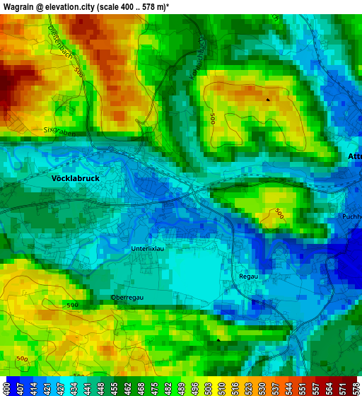
Below is the Elevation map of Wagrain, which displays elevation range with different colors. Scale of the first map is from 400 to 578 m (1312 to 1896 ft) with average elevation of 463.6 meters (=1521 ft) [note 1]
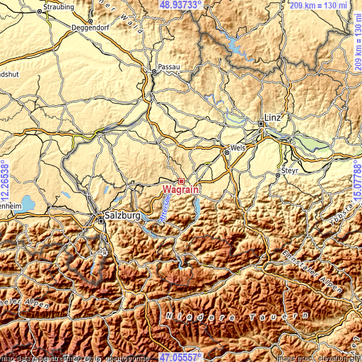
These maps also provides idea of topography and contour of this city, they are displayed at different zoom levels. More info about maps, scale and edge coordinates you can find below images.
| \ | Map #1 | Topo.Map |
| Scale [m] | 400..578 m | × |
| Scale [ft] | 1312..1896 ft | × |
| Average | 463.6 m = 1521 ft | × |
| Width | 6.54 km = 4.1 mi | 209.2 km = 130 mi |
| Height | 6.54 km = 4.1 mi | 209.2 km = 130 mi |
| ↑Max Latitude | 48.034424° | 48.93733° |
| Latitude at center | 48.00503° | 48.00503° |
| ↓Min Latitude | 47.975619° | 47.05557° |
| ← Min Longitude | 13.627685° | 12.26538° |
| Longitude center | 13.67163° | 13.67163° |
| →Max Longitude | 13.715575° | 15.07788° |
Nearby cities:
Cities around Wagrain sort by population:
• Attnang-Puchheim elevation 417 m
3.4 km,  83°
83°
• Vöcklabruck 438 m
1.2 km,  257°
257°
• Attnang 414 m
3.6 km,  68°
68°
• Timelkam 446 m
4.8 km,  268°
268°
• Puchheim 405 m
3.4 km,  99°
99°
• Dürnau 440 m
2.2 km,  246°
246°
• Schöndorf 424 m
1 km, 248°
• Schalchham 417 m
0.8 km,  178°
178°
• Niederstraß 409 m
4.4 km, 76°
• Dörfl 437 m
1.5 km,  303°
303°
• Regau 429 m
2 km,  142°
142°
• Pühret 437 m
5 km,  48°
48°
Multilingual:
 En español:
Wagrain elevación 428 m.
 En France:
Wagrain élévation 428 m.


Sources and notes:
- [note 1] Map square and city borders are not equal. Map elevation data is calculated only from area inside that square.
- [src 1] Elevation data from geonames database provided with same terms of usage.
- [src 2] The elevation map of Wagrain is generated using elevation data from NASA's 3 arcsec (90m) resolution SRTM data.
- [src 3] Base (background) map © OpenStreetMap contributors tiles are generated by Geofabrik and OpenTopoMap.
Copyright & License:
This Wagrain Elevation Map is licensed under CC BY-SA. You may reuse any part from this page, if you give a proper credit by linking to this URL:
 More info on terms of use page.