Freistadt elevation
Freistadt (Upper Austria, Politischer Bezirk Freistadt), Austria elevation is 565 meters and Freistadt elevation in feet is 1854 ft above sea level [src 1]. Freistadt is a populated place (feature code) with elevation that is 56 meters (184 ft) bigger than average city elevation in Austria.
Below is the Elevation map of Freistadt, which displays elevation range with different colors. Scale of the first map is from 516 to 883 m (1693 to 2897 ft) with average elevation of 641.5 meters (=2105 ft) [note 1]
These maps also provides idea of topography and contour of this city, they are displayed at different zoom levels. More info about maps, scale and edge coordinates you can find below images.
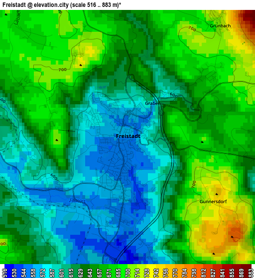
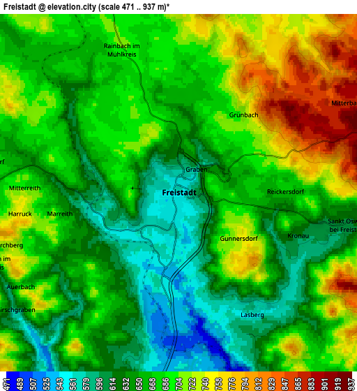
| \ | Map #1 | Map #2 | Topo.Map |
| Scale [m] | 516..883 m | 471..937 m | × |
| Scale [ft] | 1693..2897 ft | 1545..3074 ft | × |
| Average | 641.5 m = 2105 ft | 673.9 m = 2211 ft | × |
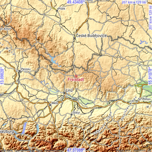
| Width | 6.47 km = 4 mi | 12.95 km = 8 mi | 207.2 km = 128.7 mi |
| Height | 6.47 km = 4 mi | 12.95 km = 8 mi | 207.2 km = 128.7 mi |
| ↑Max Latitude | 48.540134° | 48.569222° | 49.43408° |
| Latitude at center | 48.51103° | 48.51103° | 48.51103° |
| ↓Min Latitude | 48.481909° | 48.452771° | 47.57085° |
| ← Min Longitude | 14.460585° | 14.416639° | 13.09828° |
| Longitude center | 14.50453° | 14.50453° | 14.50453° |
| →Max Longitude | 14.548475° | 14.592421° | 15.91078° |
Nearby cities:
Cities around Freistadt sort by population:
• Sankt Oswald bei Freistadt elevation 612 m
5.9 km,  101°
101°
• Neumarkt im Mühlkreis 635 m
9.3 km,  189°
189°
• Schenkenfelden 737 m
10.5 km,  264°
264°
• Gutau 594 m
13.1 km,  142°
142°
• Rainbach im Mühlkreis 695 m
5.6 km,  336°
336°
• Reichenthal 685 m
9.5 km,  291°
291°
• Reichenau im Mühlkreis 678 m
13 km,  242°
242°
• Alberndorf in der Riedmark 564 m
13.4 km,  209°
209°
• Windhaag bei Freistadt 714 m
9.5 km,  26°
26°
• Ottenschlag im Mühlkreis 808 m
10.1 km, 240°
• Haibach im Mühlkreis 816 m
14 km, 237°
• Sonnberg im Mühlkreis 824 m
15.3 km,  248°
248°
Multilingual:
 En español:
Freistadt elevación 565 m.
 En France:
Freistadt élévation 565 m.
 Auf Deutsch:
Freistadt höhe über dem Meeresspiegel ist 565 m.

Sources and notes:
- [note 1] Map square and city borders are not equal. Map elevation data is calculated only from area inside that square.
- [src 1] Elevation data from geonames database provided with same terms of usage.
- [src 2] The elevation map of Freistadt is generated using elevation data from NASA's 3 arcsec (90m) resolution SRTM data.
- [src 3] Base (background) map © OpenStreetMap contributors tiles are generated by Geofabrik and OpenTopoMap.
Copyright & License:
This Freistadt Elevation Map is licensed under CC BY-SA. You may reuse any part from this page, if you give a proper credit by linking to this URL:
 More info on terms of use page.