Reichenthal elevation
Reichenthal (Upper Austria, Politischer Bezirk Urfahr-Umgebung), Austria elevation is 685 meters and Reichenthal elevation in feet is 2247 ft above sea level [src 1]. Reichenthal is a seat of a third-order administrative division (feature code) with elevation that is 176 meters (577 ft) bigger than average city elevation in Austria.
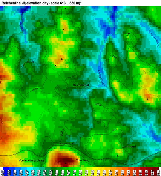
Below is the Elevation map of Reichenthal, which displays elevation range with different colors. Scale of the first map is from 613 to 836 m (2011 to 2743 ft) with average elevation of 697.7 meters (=2289 ft) [note 1]
These maps also provides idea of topography and contour of this city, they are displayed at different zoom levels. More info about maps, scale and edge coordinates you can find below images.
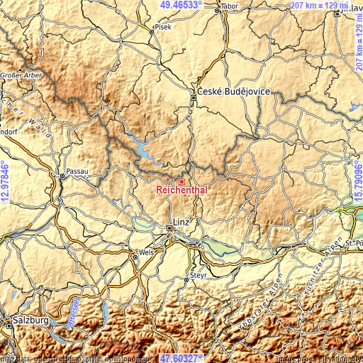
| \ | Map #1 | Topo.Map |
| Scale [m] | 613..836 m | × |
| Scale [ft] | 2011..2743 ft | × |
| Average | 697.7 m = 2289 ft | × |
| Width | 6.47 km = 4 mi | 207 km = 128.6 mi |
| Height | 6.47 km = 4 mi | 207 km = 128.6 mi |
| ↑Max Latitude | 48.571946° | 49.46533° |
| Latitude at center | 48.54286° | 48.54286° |
| ↓Min Latitude | 48.513757° | 47.60327° |
| ← Min Longitude | 14.340765° | 12.97846° |
| Longitude center | 14.38471° | 14.38471° |
| →Max Longitude | 14.428655° | 15.79096° |
Nearby cities:
Cities around Reichenthal sort by population:
• Freistadt elevation 565 m
9.5 km,  111°
111°
• Burgfried 744 m
7 km,  248°
248°
• Hellmonsödt 819 m
13.7 km,  207°
207°
• Schenkenfelden 737 m
4.8 km,  200°
200°
• Rainbach im Mühlkreis 695 m
6.8 km,  76°
76°
• Zwettl an der Rodl 617 m
12 km,  224°
224°
• Reichenau im Mühlkreis 678 m
9.9 km, 195°
• Windhaag bei Freistadt 714 m
14 km,  69°
69°
• Bad Leonfelden 746 m
7.1 km, 249°
• Ottenschlag im Mühlkreis 808 m
8.5 km,  180°
180°
• Haibach im Mühlkreis 816 m
11.4 km, 195°
• Sonnberg im Mühlkreis 824 m
10.6 km, 210°
Multilingual:
 En español:
Reichenthal elevación 685 m.
 En France:
Reichenthal élévation 685 m.
 Auf Deutsch:
Reichenthal höhe über dem Meeresspiegel ist 685 m.

Sources and notes:
- [note 1] Map square and city borders are not equal. Map elevation data is calculated only from area inside that square.
- [src 1] Elevation data from geonames database provided with same terms of usage.
- [src 2] The elevation map of Reichenthal is generated using elevation data from NASA's 3 arcsec (90m) resolution SRTM data.
- [src 3] Base (background) map © OpenStreetMap contributors tiles are generated by Geofabrik and OpenTopoMap.
Copyright & License:
This Reichenthal Elevation Map is licensed under CC BY-SA. You may reuse any part from this page, if you give a proper credit by linking to this URL:
 More info on terms of use page.