Gmünd elevation
Gmünd (Lower Austria, Politischer Bezirk Gmünd), Austria elevation is 497 meters and Gmünd elevation in feet is 1631 ft above sea level [src 1]. Gmünd is a seat of a third-order administrative division (feature code) with elevation that is 12 meters (39 ft) smaller than average city elevation in Austria.
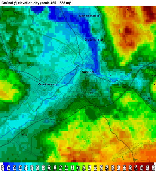
Below is the Elevation map of Gmünd, which displays elevation range with different colors. Scale of the first map is from 465 to 588 m (1526 to 1929 ft) with average elevation of 510.3 meters (=1674 ft) [note 1]
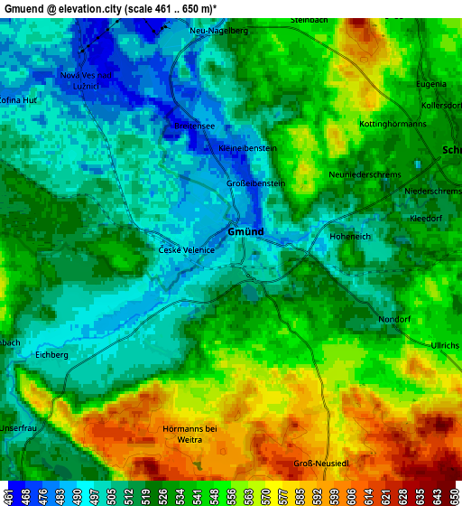
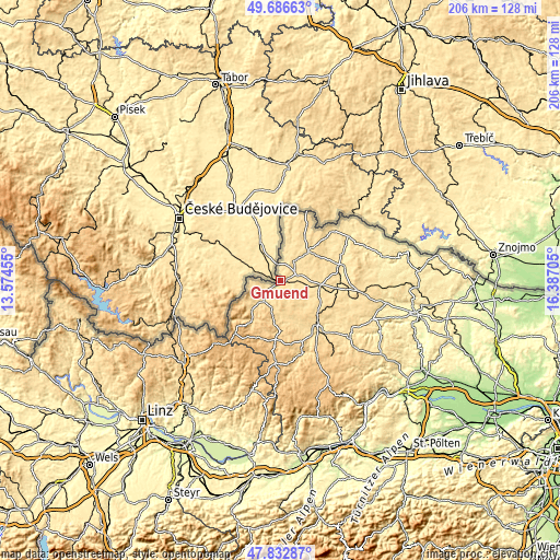
These maps also provides idea of topography and contour of this city, they are displayed at different zoom levels. More info about maps, scale and edge coordinates you can find below images.
| \ | Map #1 | Map #2 | Topo.Map |
| Scale [m] | 465..588 m | 461..650 m | × |
| Scale [ft] | 1526..1929 ft | 1512..2133 ft | × |
| Average | 510.3 m = 1674 ft | 530.5 m = 1740 ft | × |
| Width | 6.44 km = 4 mi | 12.88 km = 8 mi | 206.1 km = 128.1 mi |
| Height | 6.44 km = 4 mi | 12.88 km = 8 mi | 206.1 km = 128.1 mi |
| ↑Max Latitude | 48.797256° | 48.826196° | 49.68663° |
| Latitude at center | 48.7683° | 48.7683° | 48.7683° |
| ↓Min Latitude | 48.739327° | 48.710337° | 47.83287° |
| ← Min Longitude | 14.936855° | 14.892909° | 13.57455° |
| Longitude center | 14.9808° | 14.9808° | 14.9808° |
| →Max Longitude | 15.024745° | 15.068691° | 16.38705° |
Nearby cities:
Cities around Gmünd sort by population:
• Schrems elevation 526 m
6.5 km,  75°
75°
• Heidenreichstein 568 m
14.8 km,  42°
42°
• Weitra 569 m
10.4 km,  223°
223°
• Vitis 520 m
14.8 km,  93°
93°
• Hoheneich 505 m
3.5 km, 83°
• Echsenbach 555 m
18.2 km,  108°
108°
• Schweiggers 638 m
12.9 km,  150°
150°
• Kirchberg am Walde 577 m
9.2 km,  121°
121°
• Hirschbach 539 m
10.9 km,  104°
104°
• Eggern 581 m
19.8 km, 38°
• Waldenstein 578 m
5.1 km, 151°
• Eisgarn 555 m
18.8 km,  28°
28°
Multilingual:
 En español:
Gmünd elevación 497 m.
 En France:
Gmünd élévation 497 m.


Sources and notes:
- [note 1] Map square and city borders are not equal. Map elevation data is calculated only from area inside that square.
- [src 1] Elevation data from geonames database provided with same terms of usage.
- [src 2] The elevation map of Gmünd is generated using elevation data from NASA's 3 arcsec (90m) resolution SRTM data.
- [src 3] Base (background) map © OpenStreetMap contributors tiles are generated by Geofabrik and OpenTopoMap.
Copyright & License:
This Gmünd Elevation Map is licensed under CC BY-SA. You may reuse any part from this page, if you give a proper credit by linking to this URL:
 More info on terms of use page.