Hadres elevation
Hadres (Lower Austria, Politischer Bezirk Hollabrunn), Austria elevation is 194 meters and Hadres elevation in feet is 636 ft above sea level [src 1]. Hadres is a seat of a third-order administrative division (feature code) with elevation that is 315 meters (1033 ft) smaller than average city elevation in Austria.
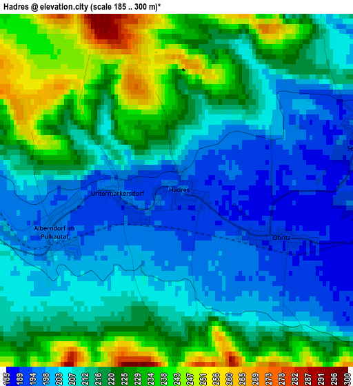
Below is the Elevation map of Hadres, which displays elevation range with different colors. Scale of the first map is from 185 to 300 m (607 to 984 ft) with average elevation of 214.7 meters (=704 ft) [note 1]
These maps also provides idea of topography and contour of this city, they are displayed at different zoom levels. More info about maps, scale and edge coordinates you can find below images.
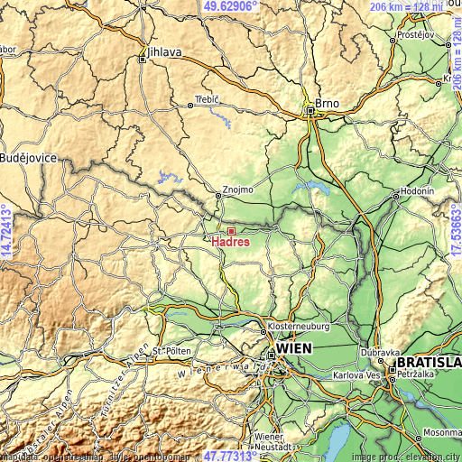
| \ | Map #1 | Topo.Map |
| Scale [m] | 185..300 m | × |
| Scale [ft] | 607..984 ft | × |
| Average | 214.7 m = 704 ft | × |
| Width | 6.45 km = 4 mi | 206.4 km = 128.3 mi |
| Height | 6.45 km = 4 mi | 206.3 km = 128.2 mi |
| ↑Max Latitude | 48.73864° | 49.62906° |
| Latitude at center | 48.70965° | 48.70965° |
| ↓Min Latitude | 48.680643° | 47.77313° |
| ← Min Longitude | 16.086435° | 14.72413° |
| Longitude center | 16.13038° | 16.13038° |
| →Max Longitude | 16.174325° | 17.53663° |
Nearby cities:
Cities around Hadres sort by population:
• Hollabrunn elevation 257 m
18.1 km,  191°
191°
• Retz 250 m
13.9 km,  292°
292°
• Zellerndorf 224 m
12.7 km,  263°
263°
• Guntersdorf 248 m
8.9 km,  221°
221°
• Haugsdorf 203 m
4 km,  266°
266°
• Wullersdorf 230 m
9.3 km, 193°
• Stronsdorf 204 m
14 km,  117°
117°
• Unterstinkenbrunn 196 m
16.5 km,  106°
106°
• Mailberg 209 m
5.5 km,  136°
136°
• Großharras 195 m
9.9 km, 121°
• Pernersdorf 214 m
8.4 km, 262°
• Schrattenthal 244 m
16.9 km, 266°
Multilingual:
 En español:
Hadres elevación 194 m.
 En France:
Hadres élévation 194 m.


Sources and notes:
- [note 1] Map square and city borders are not equal. Map elevation data is calculated only from area inside that square.
- [src 1] Elevation data from geonames database provided with same terms of usage.
- [src 2] The elevation map of Hadres is generated using elevation data from NASA's 3 arcsec (90m) resolution SRTM data.
- [src 3] Base (background) map © OpenStreetMap contributors tiles are generated by Geofabrik and OpenTopoMap.
Copyright & License:
This Hadres Elevation Map is licensed under CC BY-SA. You may reuse any part from this page, if you give a proper credit by linking to this URL:
 More info on terms of use page.