Hatzendorf elevation
Hatzendorf (Styria, Politischer Bezirk Südoststeiermark), Austria elevation is 268 meters and Hatzendorf elevation in feet is 879 ft above sea level [src 1]. Hatzendorf is a seat of a third-order administrative division (feature code) with elevation that is 241 meters (791 ft) smaller than average city elevation in Austria.
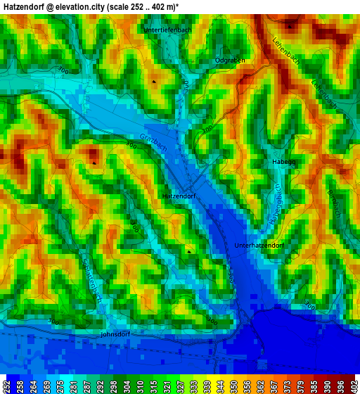
Below is the Elevation map of Hatzendorf, which displays elevation range with different colors. Scale of the first map is from 252 to 402 m (827 to 1319 ft) with average elevation of 309.6 meters (=1016 ft) [note 1]
These maps also provides idea of topography and contour of this city, they are displayed at different zoom levels. More info about maps, scale and edge coordinates you can find below images.
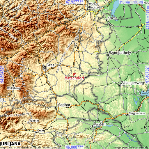
| \ | Map #1 | Topo.Map |
| Scale [m] | 252..402 m | × |
| Scale [ft] | 827..1319 ft | × |
| Average | 309.6 m = 1016 ft | × |
| Width | 6.67 km = 4.1 mi | 213.4 km = 132.6 mi |
| Height | 6.67 km = 4.1 mi | 213.4 km = 132.6 mi |
| ↑Max Latitude | 47.006835° | 47.92773° |
| Latitude at center | 46.97686° | 46.97686° |
| ↓Min Latitude | 46.946868° | 46.00877° |
| ← Min Longitude | 15.957125° | 14.59482° |
| Longitude center | 16.00107° | 16.00107° |
| →Max Longitude | 16.045015° | 17.40732° |
Nearby cities:
Cities around Hatzendorf sort by population:
• Fehring elevation 260 m
4.1 km,  172°
172°
• Pertlstein 269 m
5 km,  216°
216°
• Loipersdorf bei Fürstenfeld 263 m
7.9 km,  71°
71°
• Söchau 277 m
6.4 km,  10°
10°
• Leitersdorf im Raabtal 285 m
6.4 km,  232°
232°
• Übersbach 258 m
6.6 km,  38°
38°
• Unterlamm 312 m
4.8 km,  89°
89°
• Riegersburg 303 m
6 km,  295°
295°
• Raabau 289 m
7 km,  257°
257°
• Stein 263 m
6.9 km, 70°
• Breitenfeld an der Rittschein 340 m
7.4 km,  328°
328°
• Lödersdorf 312 m
4.8 km,  245°
245°
Multilingual:
 En español:
Hatzendorf elevación 268 m.
 En France:
Hatzendorf élévation 268 m.
 Auf Deutsch:
Hatzendorf höhe über dem Meeresspiegel ist 268 m.

Sources and notes:
- [note 1] Map square and city borders are not equal. Map elevation data is calculated only from area inside that square.
- [src 1] Elevation data from geonames database provided with same terms of usage.
- [src 2] The elevation map of Hatzendorf is generated using elevation data from NASA's 3 arcsec (90m) resolution SRTM data.
- [src 3] Base (background) map © OpenStreetMap contributors tiles are generated by Geofabrik and OpenTopoMap.
Copyright & License:
This Hatzendorf Elevation Map is licensed under CC BY-SA. You may reuse any part from this page, if you give a proper credit by linking to this URL:
 More info on terms of use page.