Stein elevation
Stein (Styria, Politischer Bezirk Hartberg-Fürstenfeld), Austria elevation is 263 meters and Stein elevation in feet is 863 ft above sea level [src 1]. Stein is a seat of a third-order administrative division (feature code) with elevation that is 246 meters (807 ft) smaller than average city elevation in Austria.
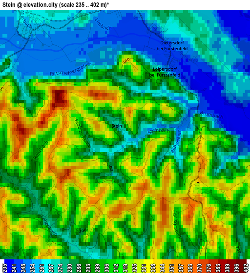
Below is the Elevation map of Stein, which displays elevation range with different colors. Scale of the first map is from 235 to 402 m (771 to 1319 ft) with average elevation of 295.5 meters (=969 ft) [note 1]
These maps also provides idea of topography and contour of this city, they are displayed at different zoom levels. More info about maps, scale and edge coordinates you can find below images.
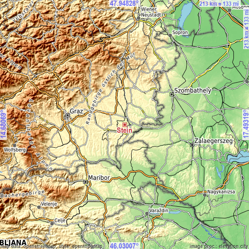
| \ | Map #1 | Topo.Map |
| Scale [m] | 235..402 m | × |
| Scale [ft] | 771..1319 ft | × |
| Average | 295.5 m = 969 ft | × |
| Width | 6.67 km = 4.1 mi | 213.3 km = 132.5 mi |
| Height | 6.67 km = 4.1 mi | 213.3 km = 132.5 mi |
| ↑Max Latitude | 47.027743° | 47.94828° |
| Latitude at center | 46.99778° | 46.99778° |
| ↓Min Latitude | 46.9678° | 46.03007° |
| ← Min Longitude | 16.042995° | 14.68069° |
| Longitude center | 16.08694° | 16.08694° |
| →Max Longitude | 16.130885° | 17.49319° |
Nearby cities:
Cities around Stein sort by population:
• Fürstenfeld elevation 255 m
5.8 km,  357°
357°
• Jennersdorf 242 m
7.8 km,  147°
147°
• Rudersdorf 245 m
6.2 km,  21°
21°
• Fehring 260 m
8.8 km,  222°
222°
• Loipersdorf bei Fürstenfeld 263 m
1 km,  76°
76°
• Hatzendorf 268 m
6.9 km,  250°
250°
• Söchau 277 m
6.6 km,  306°
306°
• Königsdorf 232 m
6.1 km,  87°
87°
• Übersbach 258 m
3.7 km,  319°
319°
• Unterlamm 312 m
2.9 km, 217°
• Altenmarkt bei Fürstenfeld 257 m
8.2 km,  338°
338°
• Eltendorf 241 m
8.8 km, 82°
Multilingual:
 En español:
Stein elevación 263 m.
 En France:
Stein élévation 263 m.


Sources and notes:
- [note 1] Map square and city borders are not equal. Map elevation data is calculated only from area inside that square.
- [src 1] Elevation data from geonames database provided with same terms of usage.
- [src 2] The elevation map of Stein is generated using elevation data from NASA's 3 arcsec (90m) resolution SRTM data.
- [src 3] Base (background) map © OpenStreetMap contributors tiles are generated by Geofabrik and OpenTopoMap.
Copyright & License:
This Stein Elevation Map is licensed under CC BY-SA. You may reuse any part from this page, if you give a proper credit by linking to this URL:
 More info on terms of use page.