Heiligenblut elevation
Heiligenblut (Carinthia, Politischer Bezirk Spittal an der Drau), Austria elevation is 1316 meters and Heiligenblut elevation in feet is 4318 ft above sea level [src 1]. Heiligenblut is a seat of a third-order administrative division (feature code) with elevation that is 807 meters (2648 ft) bigger than average city elevation in Austria.
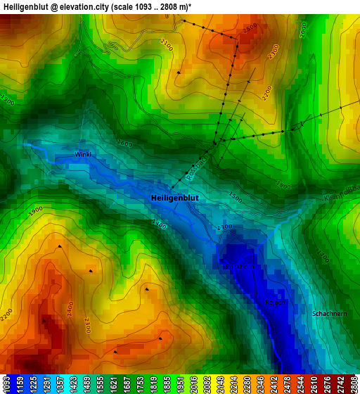
Below is the Elevation map of Heiligenblut, which displays elevation range with different colors. Scale of the first map is from 1093 to 2808 m (3586 to 9213 ft) with average elevation of 1858.6 meters (=6098 ft) [note 1]
These maps also provides idea of topography and contour of this city, they are displayed at different zoom levels. More info about maps, scale and edge coordinates you can find below images.
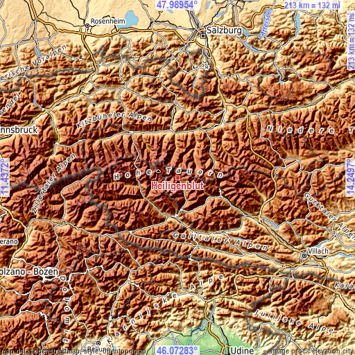
| \ | Map #1 | Topo.Map |
| Scale [m] | 1093..2808 m | × |
| Scale [ft] | 3586..9213 ft | × |
| Average | 1858.6 m = 6098 ft | × |
| Width | 6.66 km = 4.1 mi | 213.1 km = 132.4 mi |
| Height | 6.66 km = 4.1 mi | 213.1 km = 132.4 mi |
| ↑Max Latitude | 47.06973° | 47.98954° |
| Latitude at center | 47.03979° | 47.03979° |
| ↓Min Latitude | 47.009833° | 46.07283° |
| ← Min Longitude | 12.799505° | 11.4372° |
| Longitude center | 12.84345° | 12.84345° |
| →Max Longitude | 12.887395° | 14.2497° |
Nearby cities:
Cities around Heiligenblut sort by population:
• Debant elevation 674 m
23 km,  185°
185°
• Dölsach 836 m
23.5 km,  179°
179°
• Oberlienz 817 m
23 km,  201°
201°
• Ainet 727 m
22.6 km,  211°
211°
• Winklern 977 m
18.6 km,  172°
172°
• Stall 967 m
22.2 km,  138°
138°
• Schlaiten 867 m
22.9 km,  218°
218°
• Rangersdorf 860 m
21.5 km,  158°
158°
• Thurn 985 m
21.8 km, 195°
• Mörtschach 1150 m
14.1 km, 156°
• Kals am Großglockner 1338 m
15.6 km,  254°
254°
• Großkirchheim 1012 m
8.5 km,  151°
151°
Multilingual:
 En español:
Heiligenblut elevación 1316 m.
 En France:
Heiligenblut élévation 1316 m.
 Auf Deutsch:
Heiligenblut, Heiligenblut am Großglockner höhe über dem Meeresspiegel ist 1316 m.
 На русском:
Хайлигенблют, Хайлигенблут высота над уровнем моря 1316 м
Sources and notes:
- [note 1] Map square and city borders are not equal. Map elevation data is calculated only from area inside that square.
- [src 1] Elevation data from geonames database provided with same terms of usage.
- [src 2] The elevation map of Heiligenblut is generated using elevation data from NASA's 3 arcsec (90m) resolution SRTM data.
- [src 3] Base (background) map © OpenStreetMap contributors tiles are generated by Geofabrik and OpenTopoMap.
Copyright & License:
This Heiligenblut Elevation Map is licensed under CC BY-SA. You may reuse any part from this page, if you give a proper credit by linking to this URL:
 More info on terms of use page.