Heiligeneich elevation
Heiligeneich (Lower Austria, Politischer Bezirk Tulln), Austria elevation is 201 meters and Heiligeneich elevation in feet is 659 ft above sea level [src 1]. Heiligeneich is a populated place (feature code) with elevation that is 308 meters (1010 ft) smaller than average city elevation in Austria.
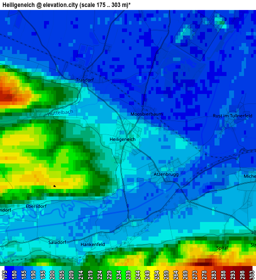
Below is the Elevation map of Heiligeneich, which displays elevation range with different colors. Scale of the first map is from 175 to 303 m (574 to 994 ft) with average elevation of 198.1 meters (=650 ft) [note 1]
These maps also provides idea of topography and contour of this city, they are displayed at different zoom levels. More info about maps, scale and edge coordinates you can find below images.
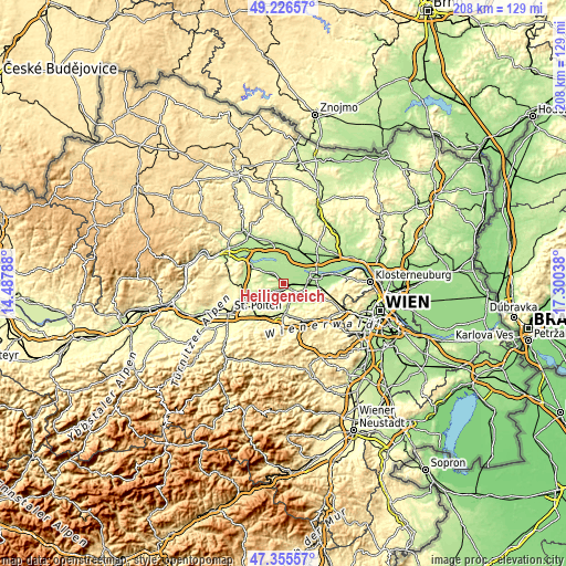
| \ | Map #1 | Topo.Map |
| Scale [m] | 175..303 m | × |
| Scale [ft] | 574..994 ft | × |
| Average | 198.1 m = 650 ft | × |
| Width | 6.5 km = 4 mi | 208 km = 129.2 mi |
| Height | 6.5 km = 4 mi | 208 km = 129.2 mi |
| ↑Max Latitude | 48.328866° | 49.22657° |
| Latitude at center | 48.29964° | 48.29964° |
| ↓Min Latitude | 48.270398° | 47.35557° |
| ← Min Longitude | 15.850185° | 14.48788° |
| Longitude center | 15.89413° | 15.89413° |
| →Max Longitude | 15.938075° | 17.30038° |
Nearby cities:
Cities around Heiligeneich sort by population:
• Sieghartskirchen elevation 198 m
10 km,  119°
119°
• Neulengbach 229 m
11.4 km,  176°
176°
• Erpersdorf 185 m
5 km,  20°
20°
• Langenrohr 179 m
8.6 km,  86°
86°
• Michelhausen 189 m
3.5 km,  106°
106°
• Zwentendorf 184 m
5.2 km,  13°
13°
• Stollhofen 189 m
11.5 km,  300°
300°
• Haag 245 m
12.2 km, 177°
• Würmla 229 m
5.6 km,  206°
206°
• Atzenbrugg 191 m
1.3 km,  136°
136°
• Asperhofen 207 m
6.4 km,  158°
158°
• Kapelln 212 m
11.1 km,  245°
245°
Multilingual:
 En español:
Heiligeneich elevación 201 m.
 En France:
Heiligeneich élévation 201 m.
 Auf Deutsch:
Heiligeneich höhe über dem Meeresspiegel ist 201 m.

Sources and notes:
- [note 1] Map square and city borders are not equal. Map elevation data is calculated only from area inside that square.
- [src 1] Elevation data from geonames database provided with same terms of usage.
- [src 2] The elevation map of Heiligeneich is generated using elevation data from NASA's 3 arcsec (90m) resolution SRTM data.
- [src 3] Base (background) map © OpenStreetMap contributors tiles are generated by Geofabrik and OpenTopoMap.
Copyright & License:
This Heiligeneich Elevation Map is licensed under CC BY-SA. You may reuse any part from this page, if you give a proper credit by linking to this URL:
 More info on terms of use page.