Hermagor elevation
Hermagor (Carinthia, Politischer Bezirk Hermagor), Austria elevation is 605 meters and Hermagor elevation in feet is 1985 ft above sea level [src 1]. Hermagor is a seat of a second-order administrative division (feature code) with elevation that is 96 meters (315 ft) bigger than average city elevation in Austria.
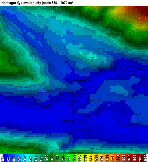
Below is the Elevation map of Hermagor, which displays elevation range with different colors. Scale of the first map is from 568 to 2070 m (1864 to 6791 ft) with average elevation of 765.9 meters (=2513 ft) [note 1]
These maps also provides idea of topography and contour of this city, they are displayed at different zoom levels. More info about maps, scale and edge coordinates you can find below images.
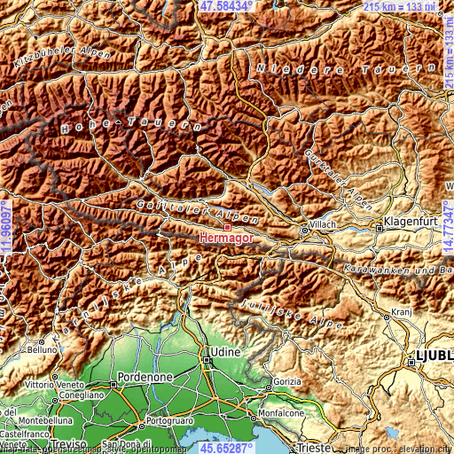
| \ | Map #1 | Topo.Map |
| Scale [m] | 568..2070 m | × |
| Scale [ft] | 1864..6791 ft | × |
| Average | 765.9 m = 2513 ft | × |
| Width | 6.71 km = 4.2 mi | 214.8 km = 133.5 mi |
| Height | 6.71 km = 4.2 mi | 214.7 km = 133.4 mi |
| ↑Max Latitude | 46.657391° | 47.58434° |
| Latitude at center | 46.62722° | 46.62722° |
| ↓Min Latitude | 46.597032° | 45.65287° |
| ← Min Longitude | 13.323275° | 11.96097° |
| Longitude center | 13.36722° | 13.36722° |
| →Max Longitude | 13.411165° | 14.77347° |
Nearby cities:
Cities around Hermagor sort by population:
• Spittal an der Drau elevation 553 m
21.7 km,  27°
27°
• Steinfeld 623 m
17.1 km,  328°
328°
• Sachsenburg 557 m
22.5 km,  357°
357°
• Greifenburg 640 m
19.8 km,  313°
313°
• Paternion 513 m
22.7 km,  64°
64°
• Baldramsdorf 576 m
20.4 km,  18°
18°
• Ferndorf 534 m
23.2 km, 58°
• Feistritz an der Gail 567 m
19.1 km,  106°
106°
• Dellach 673 m
22.3 km,  279°
279°
• Kirchbach 639 m
14 km, 276°
• Stockenboi 872 m
16.2 km,  47°
47°
• Berg im Drautal 733 m
22.3 km, 307°
Multilingual:
 En español:
Hermagor elevación 605 m.
 En France:
Hermagor élévation 605 m.
 Auf Deutsch:
Hermagor höhe über dem Meeresspiegel ist 605 m.

Sources and notes:
- [note 1] Map square and city borders are not equal. Map elevation data is calculated only from area inside that square.
- [src 1] Elevation data from geonames database provided with same terms of usage.
- [src 2] The elevation map of Hermagor is generated using elevation data from NASA's 3 arcsec (90m) resolution SRTM data.
- [src 3] Base (background) map © OpenStreetMap contributors tiles are generated by Geofabrik and OpenTopoMap.
Copyright & License:
This Hermagor Elevation Map is licensed under CC BY-SA. You may reuse any part from this page, if you give a proper credit by linking to this URL:
 More info on terms of use page.