Paternion elevation
Paternion (Carinthia, Politischer Bezirk Villach Land), Austria elevation is 513 meters and Paternion elevation in feet is 1683 ft above sea level [src 1]. Paternion is a seat of a third-order administrative division (feature code) with elevation that is 4 meters (13 ft) bigger than average city elevation in Austria.
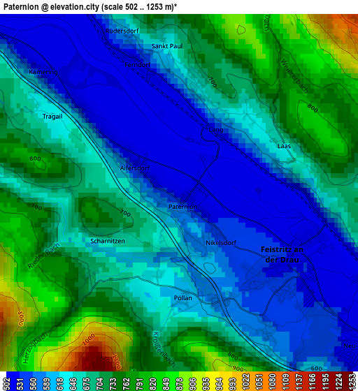
Below is the Elevation map of Paternion, which displays elevation range with different colors. Scale of the first map is from 502 to 1253 m (1647 to 4111 ft) with average elevation of 664.3 meters (=2179 ft) [note 1]
These maps also provides idea of topography and contour of this city, they are displayed at different zoom levels. More info about maps, scale and edge coordinates you can find below images.
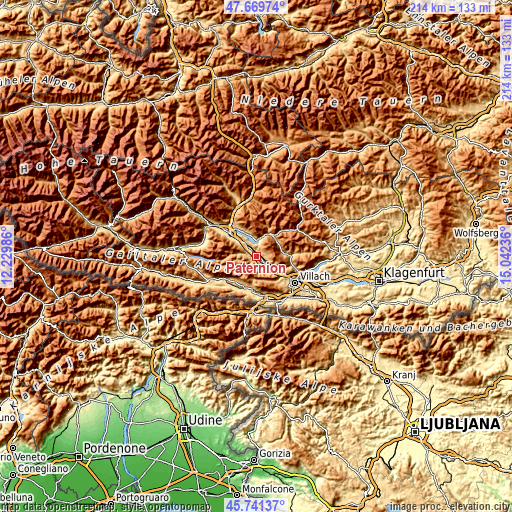
| \ | Map #1 | Topo.Map |
| Scale [m] | 502..1253 m | × |
| Scale [ft] | 1647..4111 ft | × |
| Average | 664.3 m = 2179 ft | × |
| Width | 6.7 km = 4.2 mi | 214.4 km = 133.2 mi |
| Height | 6.7 km = 4.2 mi | 214.4 km = 133.2 mi |
| ↑Max Latitude | 46.744292° | 47.66974° |
| Latitude at center | 46.71417° | 46.71417° |
| ↓Min Latitude | 46.684031° | 45.74137° |
| ← Min Longitude | 13.592165° | 12.22986° |
| Longitude center | 13.63611° | 13.63611° |
| →Max Longitude | 13.680055° | 15.04236° |
Nearby cities:
Cities around Paternion sort by population:
• Spittal an der Drau elevation 553 m
14.1 km,  312°
312°
• Seeboden 620 m
14.9 km,  321°
321°
• Radenthein 722 m
11.2 km,  30°
30°
• Feistritz an der Drau 508 m
2.6 km,  122°
122°
• Döbriach 608 m
7.6 km,  12°
12°
• Neu-Feffernitz 500 m
4.4 km,  131°
131°
• Millstatt 695 m
10.9 km,  337°
337°
• Feld am See 759 m
11 km,  50°
50°
• Ferndorf 534 m
2.6 km, 343°
• Feistritz an der Gail 567 m
15.4 km,  188°
188°
• Fresach 751 m
4.2 km,  87°
87°
• Stockenboi 872 m
8.7 km,  278°
278°
Multilingual:
 En español:
Paternion elevación 513 m.
 En France:
Paternion élévation 513 m.
 Auf Deutsch:
Paternion höhe über dem Meeresspiegel ist 513 m.

Sources and notes:
- [note 1] Map square and city borders are not equal. Map elevation data is calculated only from area inside that square.
- [src 1] Elevation data from geonames database provided with same terms of usage.
- [src 2] The elevation map of Paternion is generated using elevation data from NASA's 3 arcsec (90m) resolution SRTM data.
- [src 3] Base (background) map © OpenStreetMap contributors tiles are generated by Geofabrik and OpenTopoMap.
Copyright & License:
This Paternion Elevation Map is licensed under CC BY-SA. You may reuse any part from this page, if you give a proper credit by linking to this URL:
 More info on terms of use page.