Hohenthurn elevation
Hohenthurn (Carinthia, Politischer Bezirk Villach Land), Austria elevation is 670 meters and Hohenthurn elevation in feet is 2198 ft above sea level [src 1]. Hohenthurn is a seat of a third-order administrative division (feature code) with elevation that is 161 meters (528 ft) bigger than average city elevation in Austria.
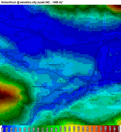
Below is the Elevation map of Hohenthurn, which displays elevation range with different colors. Scale of the first map is from 542 to 1498 m (1778 to 4915 ft) with average elevation of 682.5 meters (=2239 ft) [note 1]
These maps also provides idea of topography and contour of this city, they are displayed at different zoom levels. More info about maps, scale and edge coordinates you can find below images.
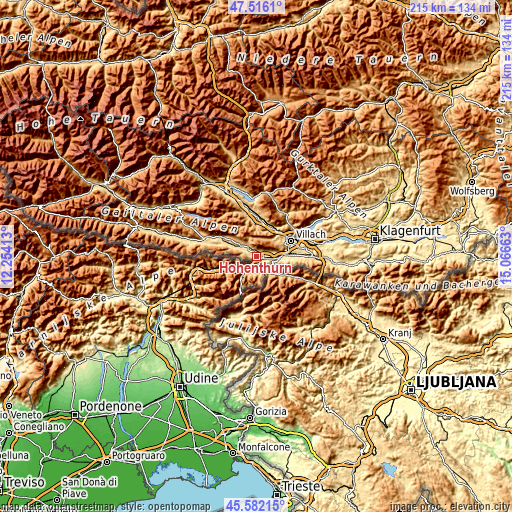
| \ | Map #1 | Topo.Map |
| Scale [m] | 542..1498 m | × |
| Scale [ft] | 1778..4915 ft | × |
| Average | 682.5 m = 2239 ft | × |
| Width | 6.72 km = 4.2 mi | 215 km = 133.6 mi |
| Height | 6.72 km = 4.2 mi | 215 km = 133.6 mi |
| ↑Max Latitude | 46.587949° | 47.5161° |
| Latitude at center | 46.55774° | 46.55774° |
| ↓Min Latitude | 46.527514° | 45.58215° |
| ← Min Longitude | 13.616435° | 12.25413° |
| Longitude center | 13.66038° | 13.66038° |
| →Max Longitude | 13.704325° | 15.06663° |
Nearby cities:
Cities around Hohenthurn sort by population:
• Villach-Innere Stadt elevation 506 m
15.5 km,  66°
66°
• Auen 492 m
14.8 km, 71°
• Völkendorf 520 m
14.2 km, 66°
• Untere Fellach 510 m
14.8 km,  59°
59°
• St. Agathen und Perau 473 m
15.9 km, 70°
• Sankt Martin 482 m
14.5 km, 62°
• Warmbad-Judendorf 508 m
13.3 km, 68°
• Arnoldstein 679 m
4 km,  108°
108°
• Fürnitz 507 m
12 km,  87°
87°
• Neu-Feffernitz 500 m
14.5 km,  5°
5°
• Gailitz 565 m
3.4 km,  84°
84°
• Feistritz an der Gail 567 m
4.7 km,  298°
298°
Multilingual:
 En español:
Hohenthurn elevación 670 m.
 En France:
Hohenthurn élévation 670 m.
 Auf Deutsch:
Hohenthurn höhe über dem Meeresspiegel ist 670 m.

Sources and notes:
- [note 1] Map square and city borders are not equal. Map elevation data is calculated only from area inside that square.
- [src 1] Elevation data from geonames database provided with same terms of usage.
- [src 2] The elevation map of Hohenthurn is generated using elevation data from NASA's 3 arcsec (90m) resolution SRTM data.
- [src 3] Base (background) map © OpenStreetMap contributors tiles are generated by Geofabrik and OpenTopoMap.
Copyright & License:
This Hohenthurn Elevation Map is licensed under CC BY-SA. You may reuse any part from this page, if you give a proper credit by linking to this URL:
 More info on terms of use page.