Auen elevation
Auen (Carinthia, Villach Stadt), Austria elevation is 492 meters and Auen elevation in feet is 1614 ft above sea level [src 1]. Auen is a section of populated place (feature code) with elevation that is 17 meters (56 ft) smaller than average city elevation in Austria.
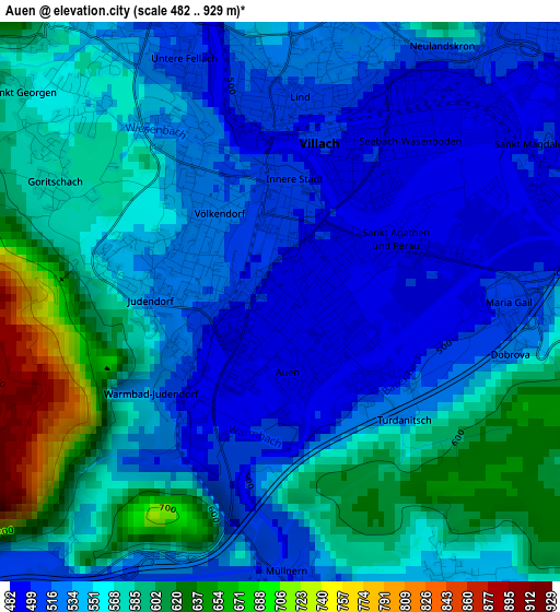
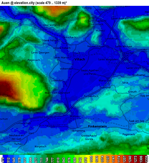
Below is the Elevation map of Auen, which displays elevation range with different colors. Scale of the first map is from 482 to 929 m (1581 to 3048 ft) with average elevation of 554.3 meters (=1819 ft) [note 1]
These maps also provides idea of topography and contour of this city, they are displayed at different zoom levels. More info about maps, scale and edge coordinates you can find below images.
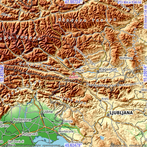
| \ | Map #1 | Map #2 | Topo.Map |
| Scale [m] | 482..929 m | 479..1339 m | × |
| Scale [ft] | 1581..3048 ft | 1572..4393 ft | × |
| Average | 554.3 m = 1819 ft | 627 m = 2057 ft | × |
| Width | 6.71 km = 4.2 mi | 13.43 km = 8.3 mi | 214.9 km = 133.5 mi |
| Height | 6.71 km = 4.2 mi | 13.43 km = 8.3 mi | 214.9 km = 133.5 mi |
| ↑Max Latitude | 46.629816° | 46.659985° | 47.55724° |
| Latitude at center | 46.59963° | 46.59963° | 46.59963° |
| ↓Min Latitude | 46.569427° | 46.539207° | 45.62479° |
| ← Min Longitude | 13.799945° | 13.755999° | 12.43764° |
| Longitude center | 13.84389° | 13.84389° | 13.84389° |
| →Max Longitude | 13.887835° | 13.931781° | 15.25014° |
Nearby cities:
Cities around Auen sort by population:
• Villach elevation 494 m
1.5 km,  37°
37°
• Villach-Innere Stadt 506 m
1.5 km,  7°
7°
• Völkendorf 520 m
1.3 km,  314°
314°
• Lind 513 m
2.5 km, 5°
• Landskron 497 m
3.6 km,  57°
57°
• Seebach 494 m
2.6 km, 42°
• Untere Fellach 510 m
3.1 km,  335°
335°
• St. Agathen und Perau 473 m
1.2 km,  51°
51°
• Sankt Martin 482 m
2.3 km,  329°
329°
• Warmbad-Judendorf 508 m
1.7 km,  276°
276°
• Sankt Leonhard 517 m
3.1 km,  21°
21°
• Sankt Magdalen 497 m
3.6 km, 57°
Multilingual:
 En español:
Auen elevación 492 m.
 En France:
Auen élévation 492 m.


Sources and notes:
- [note 1] Map square and city borders are not equal. Map elevation data is calculated only from area inside that square.
- [src 1] Elevation data from geonames database provided with same terms of usage.
- [src 2] The elevation map of Auen is generated using elevation data from NASA's 3 arcsec (90m) resolution SRTM data.
- [src 3] Base (background) map © OpenStreetMap contributors tiles are generated by Geofabrik and OpenTopoMap.
Copyright & License:
This Auen Elevation Map is licensed under CC BY-SA. You may reuse any part from this page, if you give a proper credit by linking to this URL:
 More info on terms of use page.