Hüttenberg elevation
Hüttenberg (Carinthia, Politischer Bezirk Sankt Veit an der Glan), Austria elevation is 880 meters and Hüttenberg elevation in feet is 2887 ft above sea level [src 1]. Hüttenberg is a seat of a third-order administrative division (feature code) with elevation that is 371 meters (1217 ft) bigger than average city elevation in Austria.
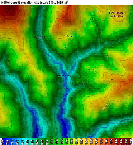
Below is the Elevation map of Hüttenberg, which displays elevation range with different colors. Scale of the first map is from 710 to 1498 m (2329 to 4915 ft) with average elevation of 1053.7 meters (=3457 ft) [note 1]
These maps also provides idea of topography and contour of this city, they are displayed at different zoom levels. More info about maps, scale and edge coordinates you can find below images.
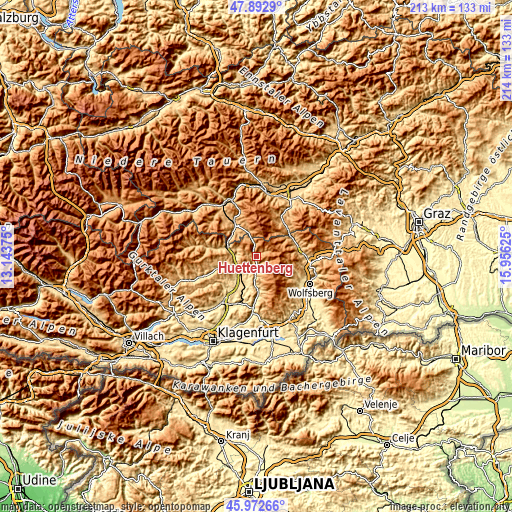
| \ | Map #1 | Topo.Map |
| Scale [m] | 710..1498 m | × |
| Scale [ft] | 2329..4915 ft | × |
| Average | 1053.7 m = 3457 ft | × |
| Width | 6.67 km = 4.1 mi | 213.5 km = 132.7 mi |
| Height | 6.67 km = 4.1 mi | 213.5 km = 132.7 mi |
| ↑Max Latitude | 46.971385° | 47.8929° |
| Latitude at center | 46.94139° | 46.94139° |
| ↓Min Latitude | 46.911378° | 45.97266° |
| ← Min Longitude | 14.506055° | 13.14375° |
| Longitude center | 14.55° | 14.55° |
| →Max Longitude | 14.593945° | 15.95625° |
Nearby cities:
Cities around Hüttenberg sort by population:
• Althofen elevation 688 m
9.5 km,  217°
217°
• Friesach 635 m
11.1 km,  278°
278°
• Treibach 611 m
10.4 km, 217°
• Klein Sankt Paul 639 m
11.7 km,  183°
183°
• Guttaring 626 m
6.9 km,  205°
205°
• Micheldorf 773 m
10.5 km,  254°
254°
• Kappel am Krappfeld 590 m
12.4 km,  202°
202°
• Kulm am Zirbitz 1145 m
13.8 km,  339°
339°
• Mühlen 960 m
10.4 km, 342°
• Dürnstein in der Steiermark 663 m
13.1 km,  293°
293°
• Mölbling 570 m
13.5 km, 221°
• Micheldorf in Kärnten 626 m
9.8 km, 252°
Multilingual:
 En español:
Hüttenberg elevación 880 m.
 En France:
Hüttenberg élévation 880 m.
 Auf Deutsch:
Hüttenberg höhe über dem Meeresspiegel ist 880 m.

Sources and notes:
- [note 1] Map square and city borders are not equal. Map elevation data is calculated only from area inside that square.
- [src 1] Elevation data from geonames database provided with same terms of usage.
- [src 2] The elevation map of Hüttenberg is generated using elevation data from NASA's 3 arcsec (90m) resolution SRTM data.
- [src 3] Base (background) map © OpenStreetMap contributors tiles are generated by Geofabrik and OpenTopoMap.
Copyright & License:
This Hüttenberg Elevation Map is licensed under CC BY-SA. You may reuse any part from this page, if you give a proper credit by linking to this URL:
 More info on terms of use page.