Mühlen elevation
Mühlen (Styria, Politischer Bezirk Murau), Austria elevation is 960 meters and Mühlen elevation in feet is 3150 ft above sea level [src 1]. Mühlen is a seat of a third-order administrative division (feature code) with elevation that is 451 meters (1480 ft) bigger than average city elevation in Austria.
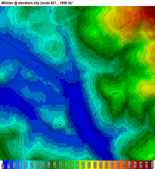
Below is the Elevation map of Mühlen, which displays elevation range with different colors. Scale of the first map is from 921 to 1958 m (3022 to 6424 ft) with average elevation of 1170.5 meters (=3840 ft) [note 1]
These maps also provides idea of topography and contour of this city, they are displayed at different zoom levels. More info about maps, scale and edge coordinates you can find below images.
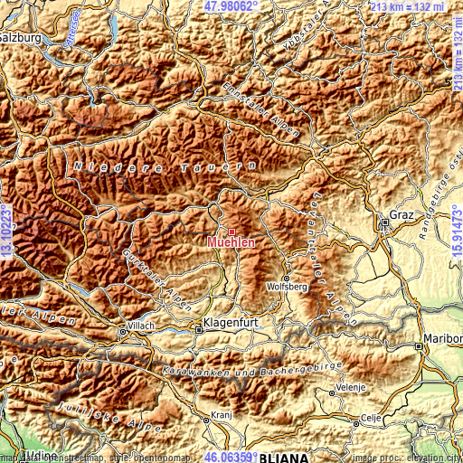
| \ | Map #1 | Topo.Map |
| Scale [m] | 921..1958 m | × |
| Scale [ft] | 3022..6424 ft | × |
| Average | 1170.5 m = 3840 ft | × |
| Width | 6.66 km = 4.1 mi | 213.2 km = 132.5 mi |
| Height | 6.66 km = 4.1 mi | 213.1 km = 132.4 mi |
| ↑Max Latitude | 47.060655° | 47.98062° |
| Latitude at center | 47.03071° | 47.03071° |
| ↓Min Latitude | 47.000748° | 46.06359° |
| ← Min Longitude | 14.464535° | 13.10223° |
| Longitude center | 14.50848° | 14.50848° |
| →Max Longitude | 14.552425° | 15.91473° |
Nearby cities:
Cities around Mühlen sort by population:
• Friesach elevation 635 m
11.4 km,  222°
222°
• Neumarkt in Steiermark 838 m
7.8 km,  308°
308°
• Obdach 899 m
13.8 km,  73°
73°
• Mariahof 959 m
11.3 km, 313°
• Micheldorf 773 m
14.5 km,  208°
208°
• Sankt Marein bei Neumarkt 826 m
7.2 km,  303°
303°
• Hüttenberg 880 m
10.4 km,  162°
162°
• Perchau am Sattel 1005 m
8.9 km,  330°
330°
• Kulm am Zirbitz 1145 m
3.5 km, 331°
• Dürnstein in der Steiermark 663 m
10 km,  241°
241°
• Zeutschach 1038 m
11.5 km,  290°
290°
• Micheldorf in Kärnten 626 m
14.3 km, 205°
Multilingual:
 En español:
Mühlen elevación 960 m.
 En France:
Mühlen élévation 960 m.


Sources and notes:
- [note 1] Map square and city borders are not equal. Map elevation data is calculated only from area inside that square.
- [src 1] Elevation data from geonames database provided with same terms of usage.
- [src 2] The elevation map of Mühlen is generated using elevation data from NASA's 3 arcsec (90m) resolution SRTM data.
- [src 3] Base (background) map © OpenStreetMap contributors tiles are generated by Geofabrik and OpenTopoMap.
Copyright & License:
This Mühlen Elevation Map is licensed under CC BY-SA. You may reuse any part from this page, if you give a proper credit by linking to this URL:
 More info on terms of use page.