Kautzen elevation
Kautzen (Lower Austria, Politischer Bezirk Waidhofen an der Thaya), Austria elevation is 521 meters and Kautzen elevation in feet is 1709 ft above sea level [src 1]. Kautzen is a seat of a third-order administrative division (feature code) with elevation that is 12 meters (39 ft) bigger than average city elevation in Austria.
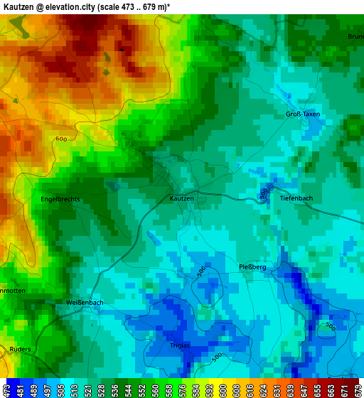
Below is the Elevation map of Kautzen, which displays elevation range with different colors. Scale of the first map is from 473 to 679 m (1552 to 2228 ft) with average elevation of 542.7 meters (=1781 ft) [note 1]
These maps also provides idea of topography and contour of this city, they are displayed at different zoom levels. More info about maps, scale and edge coordinates you can find below images.
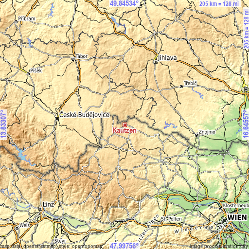
| \ | Map #1 | Topo.Map |
| Scale [m] | 473..679 m | × |
| Scale [ft] | 1552..2228 ft | × |
| Average | 542.7 m = 1781 ft | × |
| Width | 6.42 km = 4 mi | 205.5 km = 127.7 mi |
| Height | 6.42 km = 4 mi | 205.4 km = 127.6 mi |
| ↑Max Latitude | 48.958863° | 49.84534° |
| Latitude at center | 48.93° | 48.93° |
| ↓Min Latitude | 48.90112° | 47.99756° |
| ← Min Longitude | 15.195375° | 13.83307° |
| Longitude center | 15.23932° | 15.23932° |
| →Max Longitude | 15.283265° | 16.64557° |
Nearby cities:
Cities around Kautzen sort by population:
• Waidhofen an der Thaya elevation 493 m
13 km,  165°
165°
• Heidenreichstein 568 m
11.4 km,  231°
231°
• Litschau 529 m
14.3 km,  276°
276°
• Dobersberg 472 m
6.3 km,  105°
105°
• Thaya 486 m
9.1 km,  156°
156°
• Eggern 581 m
7 km,  249°
249°
• Eisgarn 555 m
10.1 km,  261°
261°
• Gastern 504 m
4.2 km,  199°
199°
• Windigsteig 485 m
18.4 km, 169°
• Haugschlag 576 m
15 km,  293°
293°
• Reingers 611 m
8.7 km,  297°
297°
• Waldkirchen an der Thaya 487 m
8.1 km,  87°
87°
Multilingual:
 En español:
Kautzen elevación 521 m.
 En France:
Kautzen élévation 521 m.


Sources and notes:
- [note 1] Map square and city borders are not equal. Map elevation data is calculated only from area inside that square.
- [src 1] Elevation data from geonames database provided with same terms of usage.
- [src 2] The elevation map of Kautzen is generated using elevation data from NASA's 3 arcsec (90m) resolution SRTM data.
- [src 3] Base (background) map © OpenStreetMap contributors tiles are generated by Geofabrik and OpenTopoMap.
Copyright & License:
This Kautzen Elevation Map is licensed under CC BY-SA. You may reuse any part from this page, if you give a proper credit by linking to this URL:
 More info on terms of use page.