Königstetten elevation
Königstetten (Lower Austria, Politischer Bezirk Tulln), Austria elevation is 176 meters and Königstetten elevation in feet is 577 ft above sea level [src 1]. Königstetten is a seat of a third-order administrative division (feature code) with elevation that is 333 meters (1093 ft) smaller than average city elevation in Austria.
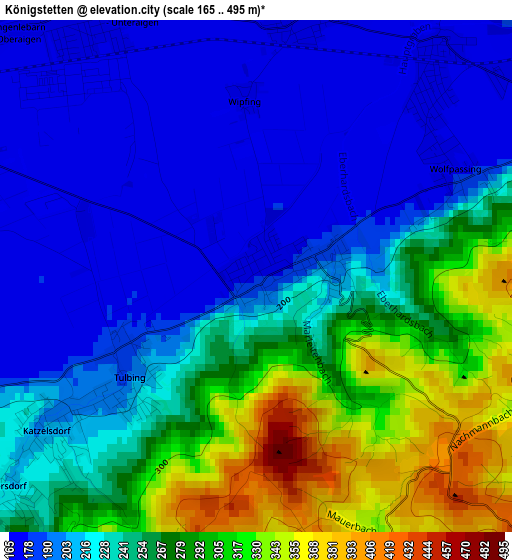
Below is the Elevation map of Königstetten, which displays elevation range with different colors. Scale of the first map is from 165 to 495 m (541 to 1624 ft) with average elevation of 240 meters (=787 ft) [note 1]
These maps also provides idea of topography and contour of this city, they are displayed at different zoom levels. More info about maps, scale and edge coordinates you can find below images.
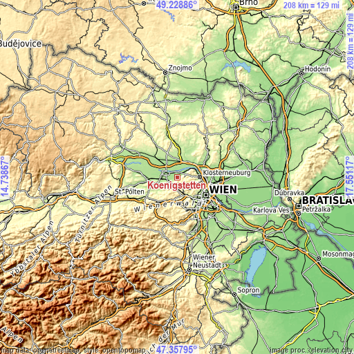
| \ | Map #1 | Topo.Map |
| Scale [m] | 165..495 m | × |
| Scale [ft] | 541..1624 ft | × |
| Average | 240 m = 787 ft | × |
| Width | 6.5 km = 4 mi | 208 km = 129.2 mi |
| Height | 6.5 km = 4 mi | 208 km = 129.2 mi |
| ↑Max Latitude | 48.331204° | 49.22886° |
| Latitude at center | 48.30198° | 48.30198° |
| ↓Min Latitude | 48.272739° | 47.35795° |
| ← Min Longitude | 16.100975° | 14.73867° |
| Longitude center | 16.14492° | 16.14492° |
| →Max Longitude | 16.188865° | 17.55117° |
Nearby cities:
Cities around Königstetten sort by population:
• Tulln elevation 175 m
7 km,  294°
294°
• Gablitz 272 m
8.2 km,  175°
175°
• Wördern 171 m
6 km,  53°
53°
• Mauerbach 281 m
6.5 km,  164°
164°
• Sankt Andrä vor dem Hagenthale 192 m
5.1 km,  64°
64°
• Hausleiten 171 m
9.6 km,  339°
339°
• Langenlebarn-Oberaigen 174 m
4 km,  321°
321°
• Zeiselmauer 173 m
3.7 km,  37°
37°
• Muckendorf an der Donau 172 m
3.4 km,  13°
13°
• Gugging 246 m
7.8 km,  80°
80°
• Katzelsdorf 204 m
3.3 km,  234°
234°
• Tulbing 183 m
1.9 km,  240°
240°
Multilingual:
 En español:
Königstetten elevación 176 m.
 En France:
Königstetten élévation 176 m.
 Auf Deutsch:
Königstetten höhe über dem Meeresspiegel ist 176 m.

Sources and notes:
- [note 1] Map square and city borders are not equal. Map elevation data is calculated only from area inside that square.
- [src 1] Elevation data from geonames database provided with same terms of usage.
- [src 2] The elevation map of Königstetten is generated using elevation data from NASA's 3 arcsec (90m) resolution SRTM data.
- [src 3] Base (background) map © OpenStreetMap contributors tiles are generated by Geofabrik and OpenTopoMap.
Copyright & License:
This Königstetten Elevation Map is licensed under CC BY-SA. You may reuse any part from this page, if you give a proper credit by linking to this URL:
 More info on terms of use page.