Krumnussbaum elevation
Krumnussbaum (Lower Austria, Politischer Bezirk Melk), Austria elevation is 215 meters and Krumnussbaum elevation in feet is 705 ft above sea level [src 1]. Krumnussbaum is a populated place (feature code) with elevation that is 294 meters (965 ft) smaller than average city elevation in Austria.
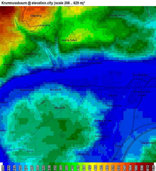
Below is the Elevation map of Krumnussbaum, which displays elevation range with different colors. Scale of the first map is from 206 to 629 m (676 to 2064 ft) with average elevation of 300.6 meters (=986 ft) [note 1]
These maps also provides idea of topography and contour of this city, they are displayed at different zoom levels. More info about maps, scale and edge coordinates you can find below images.
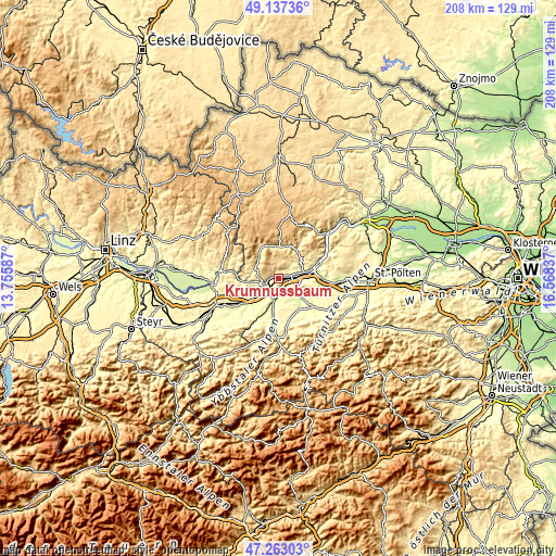
| \ | Map #1 | Topo.Map |
| Scale [m] | 206..629 m | × |
| Scale [ft] | 676..2064 ft | × |
| Average | 300.6 m = 986 ft | × |
| Width | 6.51 km = 4 mi | 208.4 km = 129.5 mi |
| Height | 6.51 km = 4 mi | 208.4 km = 129.5 mi |
| ↑Max Latitude | 48.238048° | 49.13736° |
| Latitude at center | 48.20877° | 48.20877° |
| ↓Min Latitude | 48.179476° | 47.26303° |
| ← Min Longitude | 15.118175° | 13.75587° |
| Longitude center | 15.16212° | 15.16212° |
| →Max Longitude | 15.206065° | 16.56837° |
Nearby cities:
Cities around Krumnussbaum sort by population:
• Ybbs an der Donau elevation 218 m
7.5 km,  231°
231°
• Wieselburg 258 m
8.7 km,  194°
194°
• Pöchlarn 214 m
3 km,  109°
109°
• Bergland 256 m
6.1 km,  163°
163°
• Petzenkirchen 238 m
6.9 km,  184°
184°
• Persenbeug 219 m
6 km,  246°
246°
• Klein-Pöchlarn 209 m
4.1 km,  77°
77°
• Leiben 327 m
9.3 km,  63°
63°
• Erlauf 223 m
3.2 km,  150°
150°
• Hofamt Priel 271 m
6.4 km,  257°
257°
• Marbach an der Donau 256 m
1.3 km,  314°
314°
• Maria Taferl 435 m
2 km,  354°
354°
Multilingual:
 En español:
Krumnussbaum elevación 215 m.
 En France:
Krumnussbaum élévation 215 m.
 Auf Deutsch:
Krummnußbaum höhe über dem Meeresspiegel ist 215 m.

Sources and notes:
- [note 1] Map square and city borders are not equal. Map elevation data is calculated only from area inside that square.
- [src 1] Elevation data from geonames database provided with same terms of usage.
- [src 2] The elevation map of Krumnussbaum is generated using elevation data from NASA's 3 arcsec (90m) resolution SRTM data.
- [src 3] Base (background) map © OpenStreetMap contributors tiles are generated by Geofabrik and OpenTopoMap.
Copyright & License:
This Krumnussbaum Elevation Map is licensed under CC BY-SA. You may reuse any part from this page, if you give a proper credit by linking to this URL:
 More info on terms of use page.