Laab im Walde elevation
Laab im Walde (Lower Austria, Politischer Bezirk Mödling), Austria elevation is 314 meters and Laab im Walde elevation in feet is 1030 ft above sea level [src 1]. Laab im Walde is a seat of a third-order administrative division (feature code) with elevation that is 195 meters (640 ft) smaller than average city elevation in Austria.
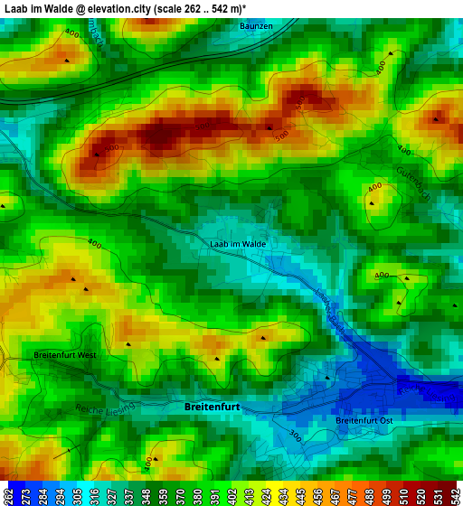
Below is the Elevation map of Laab im Walde, which displays elevation range with different colors. Scale of the first map is from 262 to 542 m (860 to 1778 ft) with average elevation of 379.9 meters (=1246 ft) [note 1]
These maps also provides idea of topography and contour of this city, they are displayed at different zoom levels. More info about maps, scale and edge coordinates you can find below images.
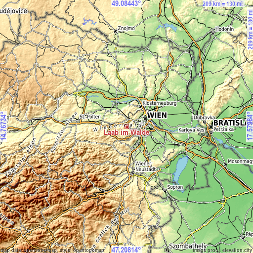
| \ | Map #1 | Topo.Map |
| Scale [m] | 262..542 m | × |
| Scale [ft] | 860..1778 ft | × |
| Average | 379.9 m = 1246 ft | × |
| Width | 6.52 km = 4.1 mi | 208.6 km = 129.6 mi |
| Height | 6.52 km = 4.1 mi | 208.6 km = 129.6 mi |
| ↑Max Latitude | 48.184168° | 49.08443° |
| Latitude at center | 48.15486° | 48.15486° |
| ↓Min Latitude | 48.125535° | 47.20814° |
| ← Min Longitude | 16.129645° | 14.76734° |
| Longitude center | 16.17359° | 16.17359° |
| →Max Longitude | 16.217535° | 17.57984° |
Nearby cities:
Cities around Laab im Walde sort by population:
• Hietzing elevation 201 m
9.8 km,  69°
69°
• Perchtoldsdorf 257 m
7.9 km,  119°
119°
• Brunn am Gebirge 223 m
9.8 km, 122°
• Purkersdorf 250 m
5.9 km,  1°
1°
• Pressbaum 317 m
7.4 km,  295°
295°
• Breitenfurt bei Wien 339 m
3 km,  216°
216°
• Gablitz 272 m
8.3 km,  350°
350°
• Hinterbrühl 254 m
9.4 km,  144°
144°
• Kaltenleutgeben 335 m
4.7 km,  155°
155°
• Gießhübl 416 m
7.8 km, 144°
• Wolfsgraben 323 m
3.9 km,  276°
276°
• Tullnerbach-Lawies 371 m
7.2 km, 301°
Multilingual:
 En español:
Laab im Walde elevación 314 m.
 En France:
Laab im Walde élévation 314 m.
 Auf Deutsch:
Laab im Walde höhe über dem Meeresspiegel ist 314 m.

Sources and notes:
- [note 1] Map square and city borders are not equal. Map elevation data is calculated only from area inside that square.
- [src 1] Elevation data from geonames database provided with same terms of usage.
- [src 2] The elevation map of Laab im Walde is generated using elevation data from NASA's 3 arcsec (90m) resolution SRTM data.
- [src 3] Base (background) map © OpenStreetMap contributors tiles are generated by Geofabrik and OpenTopoMap.
Copyright & License:
This Laab im Walde Elevation Map is licensed under CC BY-SA. You may reuse any part from this page, if you give a proper credit by linking to this URL:
 More info on terms of use page.