Lutzmannsburg elevation
Lutzmannsburg (Burgenland, Politischer Bezirk Oberpullendorf), Austria elevation is 207 meters and Lutzmannsburg elevation in feet is 679 ft above sea level [src 1]. Lutzmannsburg is a seat of a third-order administrative division (feature code) with elevation that is 302 meters (991 ft) smaller than average city elevation in Austria.
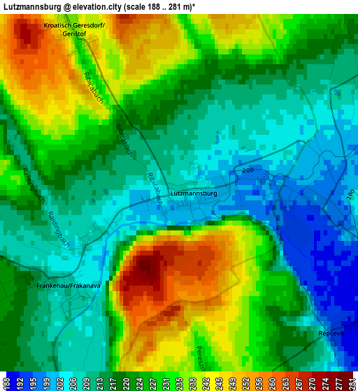
Below is the Elevation map of Lutzmannsburg, which displays elevation range with different colors. Scale of the first map is from 188 to 281 m (617 to 922 ft) with average elevation of 222.4 meters (=730 ft) [note 1]
These maps also provides idea of topography and contour of this city, they are displayed at different zoom levels. More info about maps, scale and edge coordinates you can find below images.
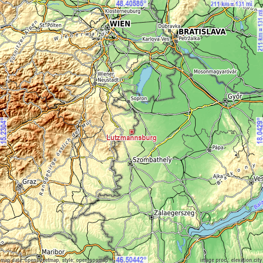
| \ | Map #1 | Topo.Map |
| Scale [m] | 188..281 m | × |
| Scale [ft] | 617..922 ft | × |
| Average | 222.4 m = 730 ft | × |
| Width | 6.61 km = 4.1 mi | 211.4 km = 131.4 mi |
| Height | 6.61 km = 4.1 mi | 211.4 km = 131.4 mi |
| ↑Max Latitude | 47.493431° | 48.40585° |
| Latitude at center | 47.46373° | 47.46373° |
| ↓Min Latitude | 47.434012° | 46.50442° |
| ← Min Longitude | 16.592705° | 15.2304° |
| Longitude center | 16.63665° | 16.63665° |
| →Max Longitude | 16.680595° | 18.0429° |
Nearby cities:
Cities around Lutzmannsburg sort by population:
• Deutschkreutz elevation 180 m
15.2 km,  359°
359°
• Oberpullendorf 246 m
10.9 km,  294°
294°
• Neckenmarkt 229 m
16.6 km,  335°
335°
• Stoob 262 m
13.9 km,  301°
301°
• Horitschon 241 m
15.3 km,  333°
333°
• Mitterpullendorf 237 m
9.3 km, 290°
• Raiding 252 m
13.9 km,  324°
324°
• Piringsdorf 304 m
16.7 km,  264°
264°
• Oberloisdorf 247 m
9.9 km, 259°
• Nikitsch 228 m
8.2 km,  12°
12°
• Unterfrauenhaid 286 m
15.8 km, 319°
• Mannersdorf an der Rabnitz 239 m
9.2 km,  244°
244°
Multilingual:
 En español:
Lutzmannsburg elevación 207 m.
 En France:
Lutzmannsburg élévation 207 m.
 Auf Deutsch:
Lutzmannsburg höhe über dem Meeresspiegel ist 207 m.

Sources and notes:
- [note 1] Map square and city borders are not equal. Map elevation data is calculated only from area inside that square.
- [src 1] Elevation data from geonames database provided with same terms of usage.
- [src 2] The elevation map of Lutzmannsburg is generated using elevation data from NASA's 3 arcsec (90m) resolution SRTM data.
- [src 3] Base (background) map © OpenStreetMap contributors tiles are generated by Geofabrik and OpenTopoMap.
Copyright & License:
This Lutzmannsburg Elevation Map is licensed under CC BY-SA. You may reuse any part from this page, if you give a proper credit by linking to this URL:
 More info on terms of use page.