Mannersdorf an der Rabnitz elevation
Mannersdorf an der Rabnitz (Burgenland, Politischer Bezirk Oberpullendorf), Austria elevation is 239 meters and Mannersdorf an der Rabnitz elevation in feet is 784 ft above sea level [src 1]. Mannersdorf an der Rabnitz is a seat of a third-order administrative division (feature code) with elevation that is 270 meters (886 ft) smaller than average city elevation in Austria.
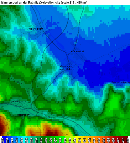
Below is the Elevation map of Mannersdorf an der Rabnitz, which displays elevation range with different colors. Scale of the first map is from 219 to 498 m (719 to 1634 ft) with average elevation of 281.3 meters (=923 ft) [note 1]
These maps also provides idea of topography and contour of this city, they are displayed at different zoom levels. More info about maps, scale and edge coordinates you can find below images.
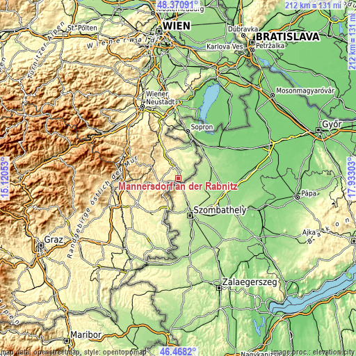
| \ | Map #1 | Topo.Map |
| Scale [m] | 219..498 m | × |
| Scale [ft] | 719..1634 ft | × |
| Average | 281.3 m = 923 ft | × |
| Width | 6.61 km = 4.1 mi | 211.6 km = 131.5 mi |
| Height | 6.61 km = 4.1 mi | 211.5 km = 131.4 mi |
| ↑Max Latitude | 47.457871° | 48.37091° |
| Latitude at center | 47.42815° | 47.42815° |
| ↓Min Latitude | 47.398412° | 46.4682° |
| ← Min Longitude | 16.482835° | 15.12053° |
| Longitude center | 16.52678° | 16.52678° |
| →Max Longitude | 16.570725° | 17.93303° |
Nearby cities:
Cities around Mannersdorf an der Rabnitz sort by population:
• Rechnitz elevation 348 m
15.2 km,  205°
205°
• Oberpullendorf 246 m
8.5 km,  348°
348°
• Stoob 262 m
11.7 km,  341°
341°
• Mitterpullendorf 237 m
7.3 km,  356°
356°
• Neutal 274 m
14.4 km, 335°
• Lockenhaus 326 m
8.6 km,  254°
254°
• Raiding 252 m
15.3 km,  1°
1°
• Piringsdorf 304 m
8.7 km,  284°
284°
• Oberloisdorf 247 m
2.6 km,  326°
326°
• Lutzmannsburg 207 m
9.2 km,  64°
64°
• Pilgersdorf 365 m
13.4 km, 276°
• Weingraben 409 m
15.5 km,  307°
307°
Multilingual:
 En español:
Mannersdorf an der Rabnitz elevación 239 m.
 En France:
Mannersdorf an der Rabnitz élévation 239 m.
 Auf Deutsch:
Mannersdorf an der Rabnitz höhe über dem Meeresspiegel ist 239 m.
 На русском:
Маннерсдорф-на-Рабениц высота над уровнем моря 239 м
Sources and notes:
- [note 1] Map square and city borders are not equal. Map elevation data is calculated only from area inside that square.
- [src 1] Elevation data from geonames database provided with same terms of usage.
- [src 2] The elevation map of Mannersdorf an der Rabnitz is generated using elevation data from NASA's 3 arcsec (90m) resolution SRTM data.
- [src 3] Base (background) map © OpenStreetMap contributors tiles are generated by Geofabrik and OpenTopoMap.
Copyright & License:
This Mannersdorf an der Rabnitz Elevation Map is licensed under CC BY-SA. You may reuse any part from this page, if you give a proper credit by linking to this URL:
 More info on terms of use page.