Mellach elevation
Mellach (Styria, Politischer Bezirk Graz-Umgebung), Austria elevation is 379 meters and Mellach elevation in feet is 1243 ft above sea level [src 1]. Mellach is a seat of a third-order administrative division (feature code) with elevation that is 130 meters (427 ft) smaller than average city elevation in Austria.
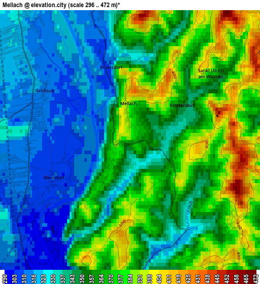
Below is the Elevation map of Mellach, which displays elevation range with different colors. Scale of the first map is from 296 to 472 m (971 to 1549 ft) with average elevation of 352.4 meters (=1156 ft) [note 1]
These maps also provides idea of topography and contour of this city, they are displayed at different zoom levels. More info about maps, scale and edge coordinates you can find below images.
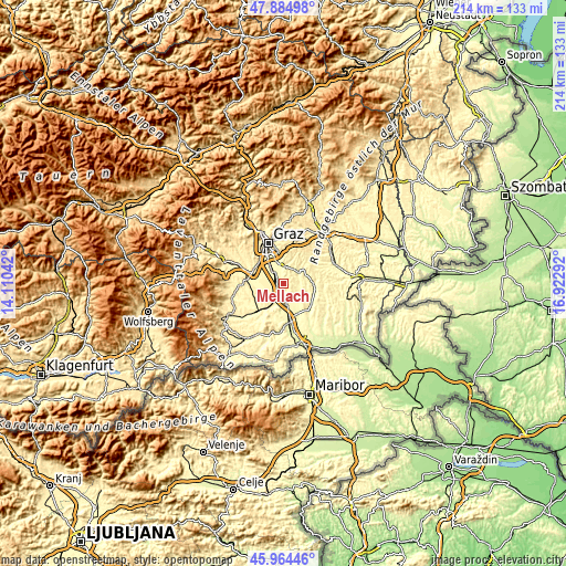
| \ | Map #1 | Topo.Map |
| Scale [m] | 296..472 m | × |
| Scale [ft] | 971..1549 ft | × |
| Average | 352.4 m = 1156 ft | × |
| Width | 6.67 km = 4.1 mi | 213.5 km = 132.7 mi |
| Height | 6.67 km = 4.1 mi | 213.5 km = 132.7 mi |
| ↑Max Latitude | 46.96333° | 47.88498° |
| Latitude at center | 46.93333° | 46.93333° |
| ↓Min Latitude | 46.903314° | 45.96446° |
| ← Min Longitude | 15.472725° | 14.11042° |
| Longitude center | 15.51667° | 15.51667° |
| →Max Longitude | 15.560615° | 16.92292° |
Nearby cities:
Cities around Mellach sort by population:
• Kalsdorf bei Graz elevation 318 m
4.5 km,  322°
322°
• Fernitz 321 m
4.7 km,  345°
345°
• Hausmannstätten 346 m
6.4 km,  356°
356°
• Wildon 320 m
5.6 km,  180°
180°
• Werndorf 309 m
2.2 km,  242°
242°
• Heiligenkreuz am Waasen 323 m
6 km,  65°
65°
• Grosssulz 311 m
2.4 km,  304°
304°
• Allerheiligen bei Wildon 393 m
3.6 km,  126°
126°
• Sankt Ulrich am Waasen 369 m
1.3 km,  90°
90°
• Wundschuh 317 m
5 km,  261°
261°
• Pirching am Traubenberg 354 m
6.6 km, 73°
• Zettling 327 m
6.6 km,  288°
288°
Multilingual:
 En español:
Mellach elevación 379 m.
 En France:
Mellach élévation 379 m.


Sources and notes:
- [note 1] Map square and city borders are not equal. Map elevation data is calculated only from area inside that square.
- [src 1] Elevation data from geonames database provided with same terms of usage.
- [src 2] The elevation map of Mellach is generated using elevation data from NASA's 3 arcsec (90m) resolution SRTM data.
- [src 3] Base (background) map © OpenStreetMap contributors tiles are generated by Geofabrik and OpenTopoMap.
Copyright & License:
This Mellach Elevation Map is licensed under CC BY-SA. You may reuse any part from this page, if you give a proper credit by linking to this URL:
 More info on terms of use page.