Zettling elevation
Zettling (Styria, Politischer Bezirk Graz-Umgebung), Austria elevation is 327 meters and Zettling elevation in feet is 1073 ft above sea level [src 1]. Zettling is a seat of a third-order administrative division (feature code) with elevation that is 182 meters (597 ft) smaller than average city elevation in Austria.
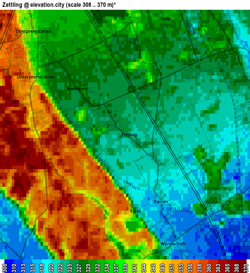
Below is the Elevation map of Zettling, which displays elevation range with different colors. Scale of the first map is from 308 to 370 m (1010 to 1214 ft) with average elevation of 333.4 meters (=1094 ft) [note 1]
These maps also provides idea of topography and contour of this city, they are displayed at different zoom levels. More info about maps, scale and edge coordinates you can find below images.
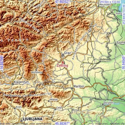
| \ | Map #1 | Topo.Map |
| Scale [m] | 308..370 m | × |
| Scale [ft] | 1010..1214 ft | × |
| Average | 333.4 m = 1094 ft | × |
| Width | 6.67 km = 4.1 mi | 213.5 km = 132.7 mi |
| Height | 6.67 km = 4.1 mi | 213.5 km = 132.7 mi |
| ↑Max Latitude | 46.982189° | 47.90352° |
| Latitude at center | 46.9522° | 46.9522° |
| ↓Min Latitude | 46.922194° | 45.98367° |
| ← Min Longitude | 15.390255° | 14.02795° |
| Longitude center | 15.4342° | 15.4342° |
| →Max Longitude | 15.478145° | 16.84045° |
Nearby cities:
Cities around Zettling sort by population:
• Seiersberg elevation 342 m
5.9 km,  333°
333°
• Kalsdorf bei Graz 318 m
3.8 km,  67°
67°
• Fernitz 321 m
5.6 km,  64°
64°
• Gössendorf 332 m
6.4 km,  37°
37°
• Werndorf 309 m
5.3 km,  125°
125°
• Wagnitz 322 m
4.2 km, 35°
• Unterpremstätten 336 m
2.7 km,  301°
301°
• Abtissendorf 329 m
5.1 km,  19°
19°
• Oberpremstätten 332 m
3.3 km,  317°
317°
• Grosssulz 311 m
4.3 km,  99°
99°
• Spatenhof 353 m
5.7 km,  281°
281°
• Wundschuh 317 m
3.1 km,  155°
155°
Multilingual:
 En español:
Zettling elevación 327 m.
 En France:
Zettling élévation 327 m.
 Auf Deutsch:
Zettling höhe über dem Meeresspiegel ist 327 m.

Sources and notes:
- [note 1] Map square and city borders are not equal. Map elevation data is calculated only from area inside that square.
- [src 1] Elevation data from geonames database provided with same terms of usage.
- [src 2] The elevation map of Zettling is generated using elevation data from NASA's 3 arcsec (90m) resolution SRTM data.
- [src 3] Base (background) map © OpenStreetMap contributors tiles are generated by Geofabrik and OpenTopoMap.
Copyright & License:
This Zettling Elevation Map is licensed under CC BY-SA. You may reuse any part from this page, if you give a proper credit by linking to this URL:
 More info on terms of use page.