Miesenbach elevation
Miesenbach (Lower Austria, Politischer Bezirk Wiener Neustadt), Austria elevation is 476 meters and Miesenbach elevation in feet is 1562 ft above sea level [src 1]. Miesenbach is a seat of a third-order administrative division (feature code) with elevation that is 33 meters (108 ft) smaller than average city elevation in Austria.
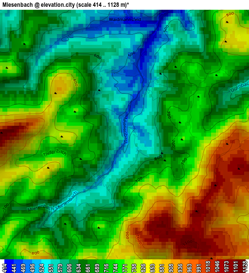
Below is the Elevation map of Miesenbach, which displays elevation range with different colors. Scale of the first map is from 414 to 1128 m (1358 to 3701 ft) with average elevation of 719.9 meters (=2362 ft) [note 1]
These maps also provides idea of topography and contour of this city, they are displayed at different zoom levels. More info about maps, scale and edge coordinates you can find below images.
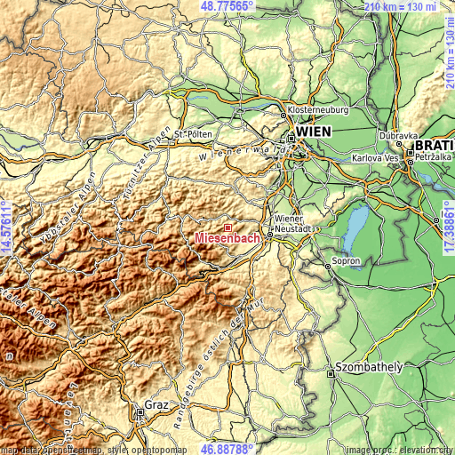
| \ | Map #1 | Topo.Map |
| Scale [m] | 414..1128 m | × |
| Scale [ft] | 1358..3701 ft | × |
| Average | 719.9 m = 2362 ft | × |
| Width | 6.56 km = 4.1 mi | 209.9 km = 130.4 mi |
| Height | 6.56 km = 4.1 mi | 209.9 km = 130.4 mi |
| ↑Max Latitude | 47.869838° | 48.77565° |
| Latitude at center | 47.84035° | 47.84035° |
| ↓Min Latitude | 47.810846° | 46.88788° |
| ← Min Longitude | 15.938415° | 14.57611° |
| Longitude center | 15.98236° | 15.98236° |
| →Max Longitude | 16.026305° | 17.38861° |
Nearby cities:
Cities around Miesenbach sort by population:
• Puchberg am Schneeberg elevation 572 m
7.8 km,  220°
220°
• Pernitz 429 m
6.6 km,  345°
345°
• Grünbach am Schneeberg 550 m
4.8 km,  175°
175°
• Winzendorf 328 m
10.3 km,  108°
108°
• Neusiedl 449 m
5.5 km,  344°
344°
• Würflach 401 m
8.9 km,  142°
142°
• Willendorf am Steinfelde 391 m
7.9 km, 135°
• Waldegg 373 m
6 km,  58°
58°
• Waidmannsfeld 475 m
3.3 km,  358°
358°
• Muggendorf 450 m
8.6 km, 335°
• Gutenstein 480 m
8 km,  299°
299°
• Schrattenbach 556 m
6.8 km,  174°
174°
Multilingual:
 En español:
Miesenbach elevación 476 m.
 En France:
Miesenbach élévation 476 m.
 Auf Deutsch:
Miesenbach höhe über dem Meeresspiegel ist 476 m.

Sources and notes:
- [note 1] Map square and city borders are not equal. Map elevation data is calculated only from area inside that square.
- [src 1] Elevation data from geonames database provided with same terms of usage.
- [src 2] The elevation map of Miesenbach is generated using elevation data from NASA's 3 arcsec (90m) resolution SRTM data.
- [src 3] Base (background) map © OpenStreetMap contributors tiles are generated by Geofabrik and OpenTopoMap.
Copyright & License:
This Miesenbach Elevation Map is licensed under CC BY-SA. You may reuse any part from this page, if you give a proper credit by linking to this URL:
 More info on terms of use page.