Winzendorf elevation
Winzendorf (Lower Austria, Politischer Bezirk Wiener Neustadt), Austria elevation is 328 meters and Winzendorf elevation in feet is 1076 ft above sea level [src 1]. Winzendorf is a populated place (feature code) with elevation that is 181 meters (594 ft) smaller than average city elevation in Austria.
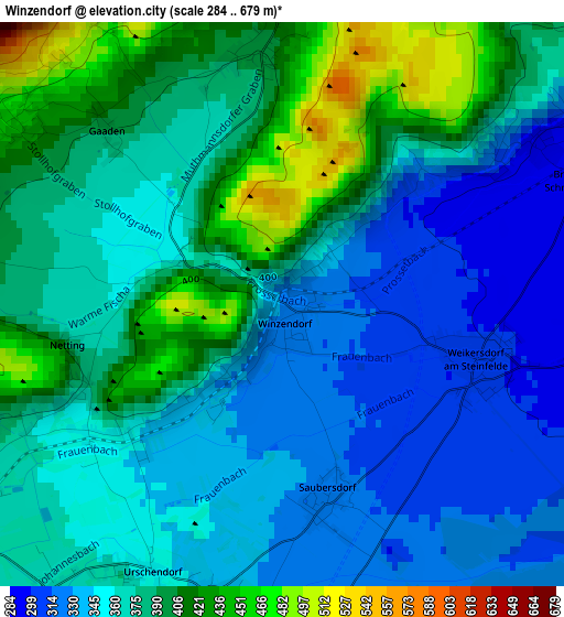
Below is the Elevation map of Winzendorf, which displays elevation range with different colors. Scale of the first map is from 284 to 679 m (932 to 2228 ft) with average elevation of 370.7 meters (=1216 ft) [note 1]
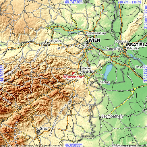
These maps also provides idea of topography and contour of this city, they are displayed at different zoom levels. More info about maps, scale and edge coordinates you can find below images.
| \ | Map #1 | Topo.Map |
| Scale [m] | 284..679 m | × |
| Scale [ft] | 932..2228 ft | × |
| Average | 370.7 m = 1216 ft | × |
| Width | 6.56 km = 4.1 mi | 210 km = 130.5 mi |
| Height | 6.56 km = 4.1 mi | 210 km = 130.5 mi |
| ↑Max Latitude | 47.841044° | 48.74736° |
| Latitude at center | 47.81154° | 47.81154° |
| ↓Min Latitude | 47.782019° | 46.85855° |
| ← Min Longitude | 16.069055° | 14.70675° |
| Longitude center | 16.113° | 16.113° |
| →Max Longitude | 16.156945° | 17.51925° |
Nearby cities:
Cities around Winzendorf sort by population:
• Wiener Neustadt elevation 270 m
8.9 km,  94°
94°
• Wöllersdorf 318 m
7.4 km,  36°
36°
• Markt Piesting 335 m
7 km,  7°
7°
• Bad Fischau 284 m
4.6 km,  61°
61°
• Steinabrückl 309 m
9.4 km,  45°
45°
• Breitenau 340 m
9 km,  165°
165°
• Brunn an der Schneebergbahn 285 m
3.7 km,  68°
68°
• Weikersdorf am Steinfelde 303 m
2.4 km,  104°
104°
• Würflach 401 m
5.8 km,  228°
228°
• Willendorf am Steinfelde 391 m
4.9 km,  239°
239°
• Hernstein 436 m
9.3 km,  356°
356°
• Waldegg 373 m
7.8 km,  324°
324°
Multilingual:
 En español:
Winzendorf elevación 328 m.
 En France:
Winzendorf élévation 328 m.
 Auf Deutsch:
Winzendorf höhe über dem Meeresspiegel ist 328 m.

Sources and notes:
- [note 1] Map square and city borders are not equal. Map elevation data is calculated only from area inside that square.
- [src 1] Elevation data from geonames database provided with same terms of usage.
- [src 2] The elevation map of Winzendorf is generated using elevation data from NASA's 3 arcsec (90m) resolution SRTM data.
- [src 3] Base (background) map © OpenStreetMap contributors tiles are generated by Geofabrik and OpenTopoMap.
Copyright & License:
This Winzendorf Elevation Map is licensed under CC BY-SA. You may reuse any part from this page, if you give a proper credit by linking to this URL:
 More info on terms of use page.