Modriach elevation
Modriach (Styria, Politischer Bezirk Voitsberg), Austria elevation is 1103 meters and Modriach elevation in feet is 3619 ft above sea level [src 1]. Modriach is a seat of a third-order administrative division (feature code) with elevation that is 594 meters (1949 ft) bigger than average city elevation in Austria.
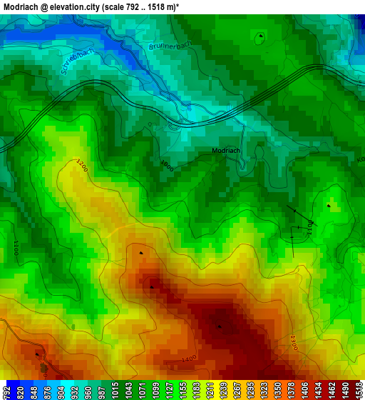
Below is the Elevation map of Modriach, which displays elevation range with different colors. Scale of the first map is from 792 to 1518 m (2598 to 4980 ft) with average elevation of 1127 meters (=3698 ft) [note 1]
These maps also provides idea of topography and contour of this city, they are displayed at different zoom levels. More info about maps, scale and edge coordinates you can find below images.
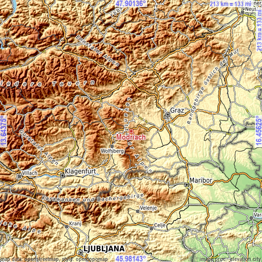
| \ | Map #1 | Topo.Map |
| Scale [m] | 792..1518 m | × |
| Scale [ft] | 2598..4980 ft | × |
| Average | 1127 m = 3698 ft | × |
| Width | 6.67 km = 4.1 mi | 213.5 km = 132.7 mi |
| Height | 6.67 km = 4.1 mi | 213.5 km = 132.7 mi |
| ↑Max Latitude | 46.97999° | 47.90136° |
| Latitude at center | 46.95° | 46.95° |
| ↓Min Latitude | 46.919993° | 45.98143° |
| ← Min Longitude | 15.006055° | 13.64375° |
| Longitude center | 15.05° | 15.05° |
| →Max Longitude | 15.093945° | 16.45625° |
Nearby cities:
Cities around Modriach sort by population:
• Voitsberg elevation 410 m
13.1 km,  36°
36°
• Köflach 451 m
13.2 km,  11°
11°
• Pichling bei Köflach 484 m
11 km, 8°
• Maria Lankowitz 507 m
12.5 km, 5°
• Rosental an der Kainach 422 m
12.6 km,  25°
25°
• Edelschrott 793 m
8 km,  1°
1°
• Ligist 377 m
13.1 km,  68°
68°
• Greisdorf 451 m
13.1 km,  101°
101°
• Pack 1094 m
6 km,  302°
302°
• Preitenegg 1069 m
9.5 km,  263°
263°
• Osterwitz 1146 m
10.5 km,  163°
163°
• Kloster 886 m
7.8 km, 161°
Multilingual:
 En español:
Modriach elevación 1103 m.
 En France:
Modriach élévation 1103 m.
 Auf Deutsch:
Modriach höhe über dem Meeresspiegel ist 1103 m.

Sources and notes:
- [note 1] Map square and city borders are not equal. Map elevation data is calculated only from area inside that square.
- [src 1] Elevation data from geonames database provided with same terms of usage.
- [src 2] The elevation map of Modriach is generated using elevation data from NASA's 3 arcsec (90m) resolution SRTM data.
- [src 3] Base (background) map © OpenStreetMap contributors tiles are generated by Geofabrik and OpenTopoMap.
Copyright & License:
This Modriach Elevation Map is licensed under CC BY-SA. You may reuse any part from this page, if you give a proper credit by linking to this URL:
 More info on terms of use page.