Ligist elevation
Ligist (Styria, Politischer Bezirk Voitsberg), Austria elevation is 377 meters and Ligist elevation in feet is 1237 ft above sea level [src 1]. Ligist is a seat of a third-order administrative division (feature code) with elevation that is 132 meters (433 ft) smaller than average city elevation in Austria.
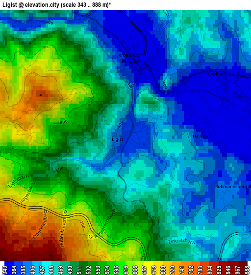
Below is the Elevation map of Ligist, which displays elevation range with different colors. Scale of the first map is from 343 to 888 m (1125 to 2913 ft) with average elevation of 494.5 meters (=1622 ft) [note 1]
These maps also provides idea of topography and contour of this city, they are displayed at different zoom levels. More info about maps, scale and edge coordinates you can find below images.
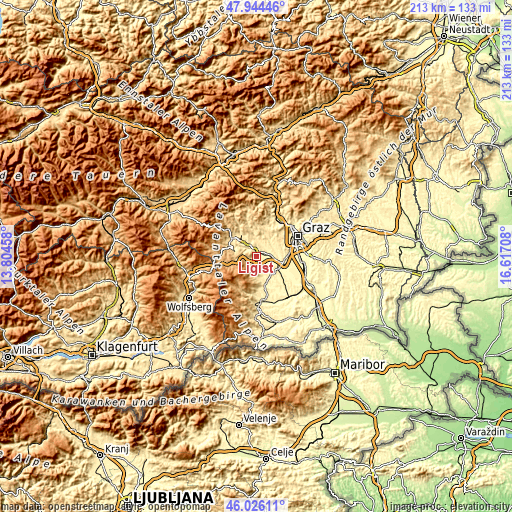
| \ | Map #1 | Topo.Map |
| Scale [m] | 343..888 m | × |
| Scale [ft] | 1125..2913 ft | × |
| Average | 494.5 m = 1622 ft | × |
| Width | 6.67 km = 4.1 mi | 213.3 km = 132.5 mi |
| Height | 6.67 km = 4.1 mi | 213.3 km = 132.5 mi |
| ↑Max Latitude | 47.023856° | 47.94446° |
| Latitude at center | 46.99389° | 46.99389° |
| ↓Min Latitude | 46.963908° | 46.02611° |
| ← Min Longitude | 15.166885° | 13.80458° |
| Longitude center | 15.21083° | 15.21083° |
| →Max Longitude | 15.254775° | 16.61708° |
Nearby cities:
Cities around Ligist sort by population:
• Voitsberg elevation 410 m
7.1 km,  322°
322°
• Rosental an der Kainach 422 m
9.3 km,  313°
313°
• Stallhofen 413 m
6.3 km,  4°
4°
• Krottendorf bei Ligist 358 m
2.6 km,  9°
9°
• Hitzendorf 369 m
8.1 km,  57°
57°
• Kleinsöding 343 m
5.5 km,  82°
82°
• Sankt Stefan ob Stainz 376 m
8.1 km,  153°
153°
• Mooskirchen 340 m
5.3 km,  104°
104°
• Sankt Bartholomä 479 m
7.7 km,  28°
28°
• Greisdorf 451 m
7.5 km,  175°
175°
• Attendorf 383 m
9.8 km, 83°
• Gundersdorf 506 m
5.2 km,  160°
160°
Multilingual:
 En español:
Ligist elevación 377 m.
 En France:
Ligist élévation 377 m.


Sources and notes:
- [note 1] Map square and city borders are not equal. Map elevation data is calculated only from area inside that square.
- [src 1] Elevation data from geonames database provided with same terms of usage.
- [src 2] The elevation map of Ligist is generated using elevation data from NASA's 3 arcsec (90m) resolution SRTM data.
- [src 3] Base (background) map © OpenStreetMap contributors tiles are generated by Geofabrik and OpenTopoMap.
Copyright & License:
This Ligist Elevation Map is licensed under CC BY-SA. You may reuse any part from this page, if you give a proper credit by linking to this URL:
 More info on terms of use page.