Ottenschlag elevation
Ottenschlag (Lower Austria, Politischer Bezirk Zwettl), Austria elevation is 849 meters and Ottenschlag elevation in feet is 2785 ft above sea level [src 1]. Ottenschlag is a seat of a third-order administrative division (feature code) with elevation that is 340 meters (1115 ft) bigger than average city elevation in Austria.
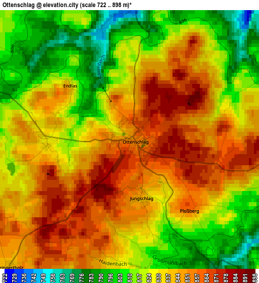
Below is the Elevation map of Ottenschlag, which displays elevation range with different colors. Scale of the first map is from 722 to 898 m (2369 to 2946 ft) with average elevation of 831.6 meters (=2728 ft) [note 1]
These maps also provides idea of topography and contour of this city, they are displayed at different zoom levels. More info about maps, scale and edge coordinates you can find below images.
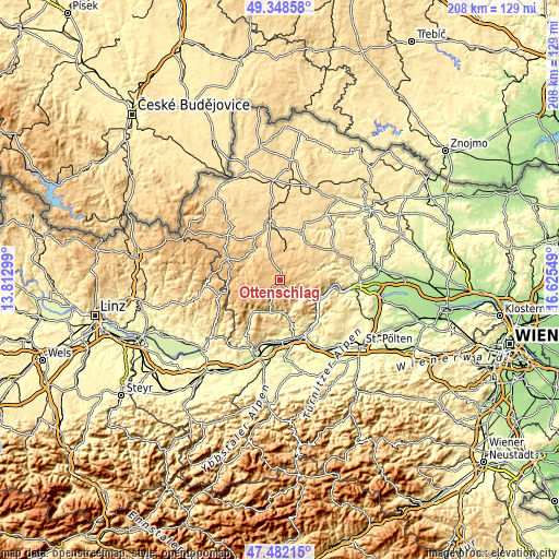
| \ | Map #1 | Topo.Map |
| Scale [m] | 722..898 m | × |
| Scale [ft] | 2369..2946 ft | × |
| Average | 831.6 m = 2728 ft | × |
| Width | 6.49 km = 4 mi | 207.5 km = 128.9 mi |
| Height | 6.49 km = 4 mi | 207.5 km = 128.9 mi |
| ↑Max Latitude | 48.453084° | 49.34858° |
| Latitude at center | 48.42393° | 48.42393° |
| ↓Min Latitude | 48.394759° | 47.48215° |
| ← Min Longitude | 15.175295° | 13.81299° |
| Longitude center | 15.21924° | 15.21924° |
| →Max Longitude | 15.263185° | 16.62549° |
Nearby cities:
Cities around Ottenschlag sort by population:
• Pöggstall elevation 457 m
11.9 km,  185°
185°
• Martinsberg 823 m
7.4 km,  223°
223°
• Gutenbrunn 870 m
9.9 km,  228°
228°
• Grafenschlag 780 m
9.3 km,  335°
335°
• Sallingberg 759 m
4.9 km,  12°
12°
• Weiten 344 m
14.6 km,  168°
168°
• Mühldorf 361 m
10.9 km,  120°
120°
• Raxendorf 516 m
10.1 km,  155°
155°
• Bad Traunstein 833 m
7.7 km,  282°
282°
• Schönbach 798 m
14 km, 281°
• Kirchschlag 820 m
3.4 km,  175°
175°
• Waldhausen 676 m
11.3 km,  16°
16°
Multilingual:
 En español:
Ottenschlag elevación 849 m.
 En France:
Ottenschlag élévation 849 m.
 Auf Deutsch:
Ottenschlag höhe über dem Meeresspiegel ist 849 m.

Sources and notes:
- [note 1] Map square and city borders are not equal. Map elevation data is calculated only from area inside that square.
- [src 1] Elevation data from geonames database provided with same terms of usage.
- [src 2] The elevation map of Ottenschlag is generated using elevation data from NASA's 3 arcsec (90m) resolution SRTM data.
- [src 3] Base (background) map © OpenStreetMap contributors tiles are generated by Geofabrik and OpenTopoMap.
Copyright & License:
This Ottenschlag Elevation Map is licensed under CC BY-SA. You may reuse any part from this page, if you give a proper credit by linking to this URL:
 More info on terms of use page.