Reifling elevation
Reifling (Styria, Politischer Bezirk Murtal), Austria elevation is 1187 meters and Reifling elevation in feet is 3894 ft above sea level [src 1]. Reifling is a seat of a third-order administrative division (feature code) with elevation that is 678 meters (2224 ft) bigger than average city elevation in Austria.
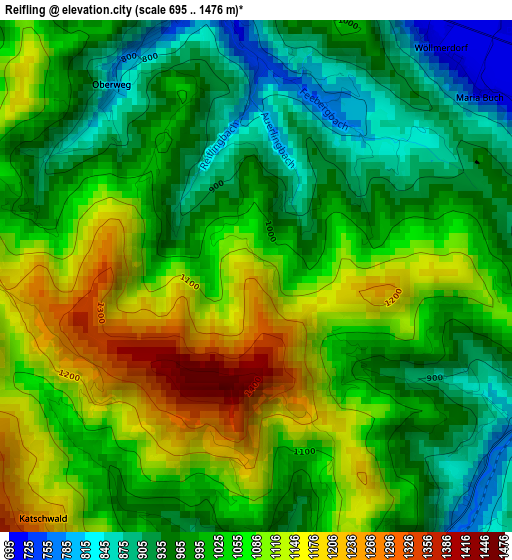
Below is the Elevation map of Reifling, which displays elevation range with different colors. Scale of the first map is from 695 to 1476 m (2280 to 4843 ft) with average elevation of 1028.6 meters (=3375 ft) [note 1]
These maps also provides idea of topography and contour of this city, they are displayed at different zoom levels. More info about maps, scale and edge coordinates you can find below images.
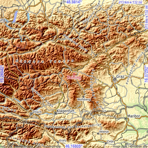
| \ | Map #1 | Topo.Map |
| Scale [m] | 695..1476 m | × |
| Scale [ft] | 2280..4843 ft | × |
| Average | 1028.6 m = 3375 ft | × |
| Width | 6.65 km = 4.1 mi | 212.7 km = 132.2 mi |
| Height | 6.65 km = 4.1 mi | 212.7 km = 132.2 mi |
| ↑Max Latitude | 47.163217° | 48.0814° |
| Latitude at center | 47.13333° | 47.13333° |
| ↓Min Latitude | 47.103426° | 46.16805° |
| ← Min Longitude | 14.622725° | 13.26042° |
| Longitude center | 14.66667° | 14.66667° |
| →Max Longitude | 14.710615° | 16.07292° |
Nearby cities:
Cities around Reifling sort by population:
• Judenburg elevation 754 m
3.7 km,  0°
0°
• Zeltweg 652 m
8.4 km,  48°
48°
• Fohnsdorf 757 m
7.5 km,  9°
9°
• Dietersdorf 726 m
7.4 km, 0°
• Obdach 899 m
7.5 km,  170°
170°
• Weißkirchen in Steiermark 690 m
5.4 km,  69°
69°
• Farrach 674 m
7.5 km,  42°
42°
• Hetzendorf 729 m
5.7 km, 12°
• Oberweg 896 m
3.1 km,  306°
306°
• Sankt Peter ob Judenburg 792 m
8.3 km, 312°
• Eppenstein 725 m
5.4 km,  95°
95°
• Flatschach 677 m
11.2 km,  34°
34°
Multilingual:
 En español:
Reifling elevación 1187 m.
 En France:
Reifling élévation 1187 m.
 Auf Deutsch:
Reifling höhe über dem Meeresspiegel ist 1187 m.

Sources and notes:
- [note 1] Map square and city borders are not equal. Map elevation data is calculated only from area inside that square.
- [src 1] Elevation data from geonames database provided with same terms of usage.
- [src 2] The elevation map of Reifling is generated using elevation data from NASA's 3 arcsec (90m) resolution SRTM data.
- [src 3] Base (background) map © OpenStreetMap contributors tiles are generated by Geofabrik and OpenTopoMap.
Copyright & License:
This Reifling Elevation Map is licensed under CC BY-SA. You may reuse any part from this page, if you give a proper credit by linking to this URL:
 More info on terms of use page.