Schörfling elevation
Schörfling (Upper Austria, Politischer Bezirk Vöcklabruck), Austria elevation is 509 meters and Schörfling elevation in feet is 1670 ft above sea level [src 1]. Schörfling is a populated place (feature code) with elevation that is 0 meters (0 ft) bigger than average city elevation in Austria.
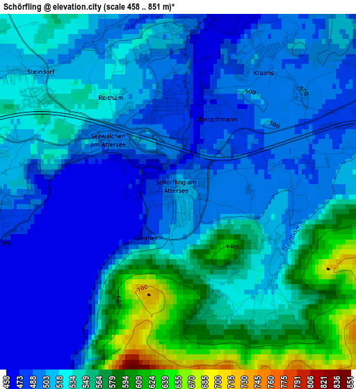
Below is the Elevation map of Schörfling, which displays elevation range with different colors. Scale of the first map is from 458 to 851 m (1503 to 2792 ft) with average elevation of 525.1 meters (=1723 ft) [note 1]
These maps also provides idea of topography and contour of this city, they are displayed at different zoom levels. More info about maps, scale and edge coordinates you can find below images.
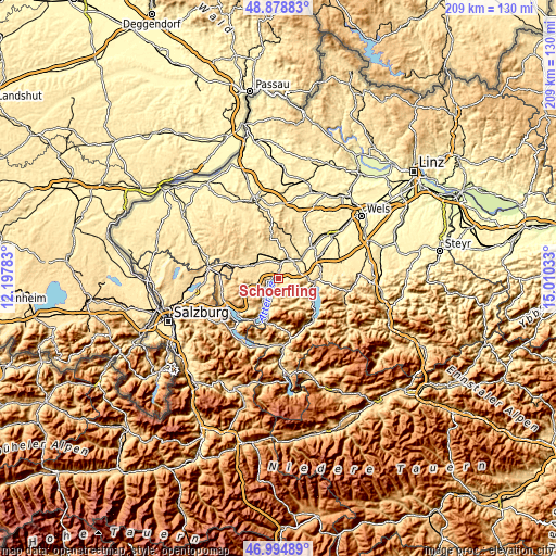
| \ | Map #1 | Topo.Map |
| Scale [m] | 458..851 m | × |
| Scale [ft] | 1503..2792 ft | × |
| Average | 525.1 m = 1723 ft | × |
| Width | 6.55 km = 4.1 mi | 209.5 km = 130.2 mi |
| Height | 6.55 km = 4.1 mi | 209.5 km = 130.2 mi |
| ↑Max Latitude | 47.974868° | 48.87883° |
| Latitude at center | 47.94544° | 47.94544° |
| ↓Min Latitude | 47.915995° | 46.99489° |
| ← Min Longitude | 13.560135° | 12.19783° |
| Longitude center | 13.60408° | 13.60408° |
| →Max Longitude | 13.648025° | 15.01033° |
Nearby cities:
Cities around Schörfling sort by population:
• Vöcklabruck elevation 438 m
7.5 km,  31°
31°
• Timelkam 446 m
6.5 km,  2°
2°
• Lenzing 485 m
3.1 km,  6°
6°
• Seewalchen 493 m
1.7 km,  297°
297°
• Dürnau 440 m
6.5 km, 27°
• Schöndorf 424 m
7.5 km, 33°
• Schalchham 417 m
7.7 km,  40°
40°
• Weyregg 477 m
5.3 km,  206°
206°
• Gampern 507 m
6.1 km,  322°
322°
• Regau 429 m
8 km,  51°
51°
• Aurach am Hongar 492 m
5.2 km,  82°
82°
• Attersee 490 m
5.8 km,  236°
236°
Multilingual:
 En español:
Schörfling elevación 509 m.
 En France:
Schörfling élévation 509 m.
 Auf Deutsch:
Schörfling höhe über dem Meeresspiegel ist 509 m.

Sources and notes:
- [note 1] Map square and city borders are not equal. Map elevation data is calculated only from area inside that square.
- [src 1] Elevation data from geonames database provided with same terms of usage.
- [src 2] The elevation map of Schörfling is generated using elevation data from NASA's 3 arcsec (90m) resolution SRTM data.
- [src 3] Base (background) map © OpenStreetMap contributors tiles are generated by Geofabrik and OpenTopoMap.
Copyright & License:
This Schörfling Elevation Map is licensed under CC BY-SA. You may reuse any part from this page, if you give a proper credit by linking to this URL:
 More info on terms of use page.