Sittersdorf elevation
Sittersdorf (Carinthia, Politischer Bezirk Völkermarkt), Austria elevation is 501 meters and Sittersdorf elevation in feet is 1644 ft above sea level [src 1]. Sittersdorf is a seat of a third-order administrative division (feature code) with elevation that is 8 meters (26 ft) smaller than average city elevation in Austria.
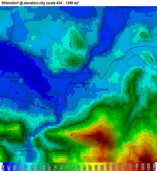
Below is the Elevation map of Sittersdorf, which displays elevation range with different colors. Scale of the first map is from 434 to 1288 m (1424 to 4226 ft) with average elevation of 622.6 meters (=2043 ft) [note 1]
These maps also provides idea of topography and contour of this city, they are displayed at different zoom levels. More info about maps, scale and edge coordinates you can find below images.
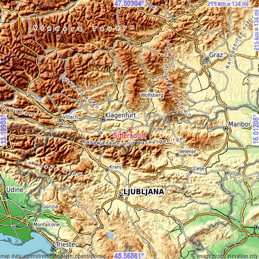
| \ | Map #1 | Topo.Map |
| Scale [m] | 434..1288 m | × |
| Scale [ft] | 1424..4226 ft | × |
| Average | 622.6 m = 2043 ft | × |
| Width | 6.72 km = 4.2 mi | 215.1 km = 133.7 mi |
| Height | 6.72 km = 4.2 mi | 215.1 km = 133.7 mi |
| ↑Max Latitude | 46.574657° | 47.50304° |
| Latitude at center | 46.54444° | 46.54444° |
| ↓Min Latitude | 46.514206° | 45.56861° |
| ← Min Longitude | 14.561885° | 13.19958° |
| Longitude center | 14.60583° | 14.60583° |
| →Max Longitude | 14.649775° | 16.01208° |
Nearby cities:
Cities around Sittersdorf sort by population:
• Völkermarkt elevation 463 m
13.3 km,  9°
9°
• Kühnsdorf 439 m
8.9 km,  15°
15°
• Bleiburg/Pliberk 485 m
15.6 km,  71°
71°
• Eberndorf 486 m
6 km,  28°
28°
• Rain 420 m
18.1 km,  291°
291°
• Niederdorf 422 m
17.7 km,  297°
297°
• Grafenstein 415 m
13.1 km,  306°
306°
• Poggersdorf 456 m
16.7 km, 314°
• Globasnitz 545 m
7.5 km,  79°
79°
• Feistritz ob Bleiburg 599 m
12.3 km,  87°
87°
• Gallizien 458 m
6.8 km,  275°
275°
• Sankt Margareten im Rosental 570 m
13.9 km,  269°
269°
Multilingual:
 En español:
Sittersdorf elevación 501 m.
 En France:
Sittersdorf élévation 501 m.
 Auf Deutsch:
Sittersdorf höhe über dem Meeresspiegel ist 501 m.

Sources and notes:
- [note 1] Map square and city borders are not equal. Map elevation data is calculated only from area inside that square.
- [src 1] Elevation data from geonames database provided with same terms of usage.
- [src 2] The elevation map of Sittersdorf is generated using elevation data from NASA's 3 arcsec (90m) resolution SRTM data.
- [src 3] Base (background) map © OpenStreetMap contributors tiles are generated by Geofabrik and OpenTopoMap.
Copyright & License:
This Sittersdorf Elevation Map is licensed under CC BY-SA. You may reuse any part from this page, if you give a proper credit by linking to this URL:
 More info on terms of use page.