Niederdorf elevation
Niederdorf (Carinthia, Politischer Bezirk Klagenfurt Land), Austria elevation is 422 meters and Niederdorf elevation in feet is 1385 ft above sea level [src 1]. Niederdorf is a populated place (feature code) with elevation that is 87 meters (285 ft) smaller than average city elevation in Austria.
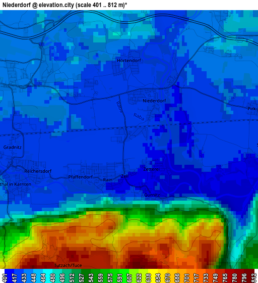
Below is the Elevation map of Niederdorf, which displays elevation range with different colors. Scale of the first map is from 401 to 812 m (1316 to 2664 ft) with average elevation of 480.9 meters (=1578 ft) [note 1]
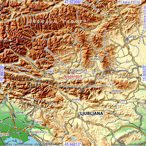
These maps also provides idea of topography and contour of this city, they are displayed at different zoom levels. More info about maps, scale and edge coordinates you can find below images.
| \ | Map #1 | Topo.Map |
| Scale [m] | 401..812 m | × |
| Scale [ft] | 1316..2664 ft | × |
| Average | 480.9 m = 1578 ft | × |
| Width | 6.71 km = 4.2 mi | 214.8 km = 133.5 mi |
| Height | 6.71 km = 4.2 mi | 214.8 km = 133.5 mi |
| ↑Max Latitude | 46.646847° | 47.57398° |
| Latitude at center | 46.61667° | 46.61667° |
| ↓Min Latitude | 46.586477° | 45.64213° |
| ← Min Longitude | 14.356055° | 12.99375° |
| Longitude center | 14.4° | 14.4° |
| →Max Longitude | 14.443945° | 15.80625° |
Nearby cities:
Cities around Niederdorf sort by population:
• Klagenfurt am Wörthersee elevation 450 m
7.3 km,  277°
277°
• Sankt Peter 438 m
4.8 km,  287°
287°
• Annabichl 454 m
7.4 km,  300°
300°
• Sankt Ruprecht 438 m
6.6 km,  253°
253°
• Völkermarkter Vorstadt 442 m
6.1 km, 277°
• St. Veiter Vorstadt 446 m
7.4 km, 283°
• Viktringer Vorstadt 436 m
6.9 km,  270°
270°
• Hörtendorf 429 m
1.9 km,  0°
0°
• Ebenthal 427 m
2.9 km, 250°
• Rain 420 m
1.7 km,  219°
219°
• Grafenstein 415 m
5.1 km,  93°
93°
• Poggersdorf 456 m
5.3 km,  45°
45°
Multilingual:
 En español:
Niederdorf elevación 422 m.
 En France:
Niederdorf élévation 422 m.
 Auf Deutsch:
Niederdorf höhe über dem Meeresspiegel ist 422 m.

Sources and notes:
- [note 1] Map square and city borders are not equal. Map elevation data is calculated only from area inside that square.
- [src 1] Elevation data from geonames database provided with same terms of usage.
- [src 2] The elevation map of Niederdorf is generated using elevation data from NASA's 3 arcsec (90m) resolution SRTM data.
- [src 3] Base (background) map © OpenStreetMap contributors tiles are generated by Geofabrik and OpenTopoMap.
Copyright & License:
This Niederdorf Elevation Map is licensed under CC BY-SA. You may reuse any part from this page, if you give a proper credit by linking to this URL:
 More info on terms of use page.