Stainz elevation
Stainz (Styria, Politischer Bezirk Deutschlandsberg), Austria elevation is 337 meters and Stainz elevation in feet is 1106 ft above sea level [src 1]. Stainz is a seat of a third-order administrative division (feature code) with elevation that is 172 meters (564 ft) smaller than average city elevation in Austria.
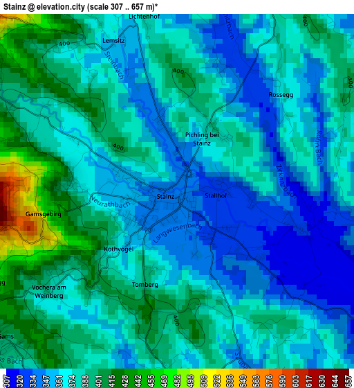
Below is the Elevation map of Stainz, which displays elevation range with different colors. Scale of the first map is from 307 to 657 m (1007 to 2156 ft) with average elevation of 375.8 meters (=1233 ft) [note 1]
These maps also provides idea of topography and contour of this city, they are displayed at different zoom levels. More info about maps, scale and edge coordinates you can find below images.
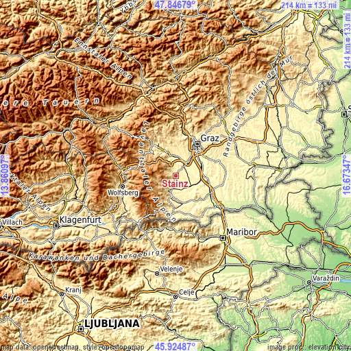
| \ | Map #1 | Topo.Map |
| Scale [m] | 307..657 m | × |
| Scale [ft] | 1007..2156 ft | × |
| Average | 375.8 m = 1233 ft | × |
| Width | 6.68 km = 4.2 mi | 213.7 km = 132.8 mi |
| Height | 6.68 km = 4.2 mi | 213.7 km = 132.8 mi |
| ↑Max Latitude | 46.924461° | 47.84679° |
| Latitude at center | 46.89444° | 46.89444° |
| ↓Min Latitude | 46.864402° | 45.92487° |
| ← Min Longitude | 15.223275° | 13.86097° |
| Longitude center | 15.26722° | 15.26722° |
| →Max Longitude | 15.311165° | 16.67347° |
Nearby cities:
Cities around Stainz sort by population:
• Deutschlandsberg elevation 362 m
9.4 km,  201°
201°
• Lannach 330 m
7.8 km,  42°
42°
• Freidorf an der Laßnitz 341 m
8.7 km,  188°
188°
• Groß Sankt Florian 309 m
8.7 km,  153°
153°
• Sankt Stefan ob Stainz 376 m
3.9 km,  350°
350°
• Sankt Josef (Weststeiermark) 351 m
5.5 km,  72°
72°
• Mooskirchen 340 m
9.7 km,  5°
5°
• Bad Gams 413 m
4.1 km,  231°
231°
• Stallhof 327 m
1.7 km,  135°
135°
• Greisdorf 451 m
5.1 km,  314°
314°
• Rassach 382 m
3.8 km,  176°
176°
• Gundersdorf 506 m
6.7 km,  337°
337°
Multilingual:
 En español:
Stainz elevación 337 m.
 En France:
Stainz élévation 337 m.


Sources and notes:
- [note 1] Map square and city borders are not equal. Map elevation data is calculated only from area inside that square.
- [src 1] Elevation data from geonames database provided with same terms of usage.
- [src 2] The elevation map of Stainz is generated using elevation data from NASA's 3 arcsec (90m) resolution SRTM data.
- [src 3] Base (background) map © OpenStreetMap contributors tiles are generated by Geofabrik and OpenTopoMap.
Copyright & License:
This Stainz Elevation Map is licensed under CC BY-SA. You may reuse any part from this page, if you give a proper credit by linking to this URL:
 More info on terms of use page.