Strassham elevation
Strassham (Upper Austria, Politischer Bezirk Eferding), Austria elevation is 268 meters and Strassham elevation in feet is 879 ft above sea level [src 1]. Strassham is a populated place (feature code) with elevation that is 241 meters (791 ft) smaller than average city elevation in Austria.
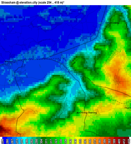
Below is the Elevation map of Strassham, which displays elevation range with different colors. Scale of the first map is from 254 to 418 m (833 to 1371 ft) with average elevation of 300.9 meters (=987 ft) [note 1]
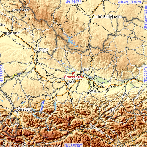
These maps also provides idea of topography and contour of this city, they are displayed at different zoom levels. More info about maps, scale and edge coordinates you can find below images.
| \ | Map #1 | Topo.Map |
| Scale [m] | 254..418 m | × |
| Scale [ft] | 833..1371 ft | × |
| Average | 300.9 m = 987 ft | × |
| Width | 6.5 km = 4 mi | 208.1 km = 129.3 mi |
| Height | 6.5 km = 4 mi | 208.1 km = 129.3 mi |
| ↑Max Latitude | 48.312715° | 49.2107° |
| Latitude at center | 48.28348° | 48.28348° |
| ↓Min Latitude | 48.254228° | 47.33912° |
| ← Min Longitude | 14.101295° | 12.73899° |
| Longitude center | 14.14524° | 14.14524° |
| →Max Longitude | 14.189185° | 15.55149° |
Nearby cities:
Cities around Strassham sort by population:
• Walding elevation 277 m
7.7 km,  6°
6°
• Ottensheim 269 m
5.9 km,  21°
21°
• Puchenau 288 m
7.4 km,  64°
64°
• Pasching 294 m
5.1 km,  121°
121°
• Hörsching 291 m
6.8 km,  159°
159°
• Alkoven 264 m
2.8 km,  279°
279°
• Rufling 331 m
5.3 km,  96°
96°
• Bergham 306 m
6.4 km,  91°
91°
• Hartheim 270 m
2.3 km,  262°
262°
• Schönering 266 m
2 km,  35°
35°
• Goldwörth 259 m
5.8 km,  325°
325°
• Holzhausen 328 m
7.6 km,  208°
208°
Multilingual:
 En español:
Strassham elevación 268 m.
 En France:
Strassham élévation 268 m.
 Auf Deutsch:
Strassham höhe über dem Meeresspiegel ist 268 m.

Sources and notes:
- [note 1] Map square and city borders are not equal. Map elevation data is calculated only from area inside that square.
- [src 1] Elevation data from geonames database provided with same terms of usage.
- [src 2] The elevation map of Strassham is generated using elevation data from NASA's 3 arcsec (90m) resolution SRTM data.
- [src 3] Base (background) map © OpenStreetMap contributors tiles are generated by Geofabrik and OpenTopoMap.
Copyright & License:
This Strassham Elevation Map is licensed under CC BY-SA. You may reuse any part from this page, if you give a proper credit by linking to this URL:
 More info on terms of use page.