Tattendorf elevation
Tattendorf (Lower Austria, Politischer Bezirk Baden), Austria elevation is 229 meters and Tattendorf elevation in feet is 751 ft above sea level [src 1]. Tattendorf is a seat of a third-order administrative division (feature code) with elevation that is 280 meters (919 ft) smaller than average city elevation in Austria.
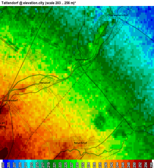
Below is the Elevation map of Tattendorf, which displays elevation range with different colors. Scale of the first map is from 203 to 256 m (666 to 840 ft) with average elevation of 227.9 meters (=748 ft) [note 1]
These maps also provides idea of topography and contour of this city, they are displayed at different zoom levels. More info about maps, scale and edge coordinates you can find below images.
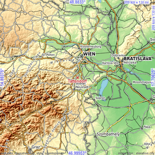
| \ | Map #1 | Topo.Map |
| Scale [m] | 203..256 m | × |
| Scale [ft] | 666..840 ft | × |
| Average | 227.9 m = 748 ft | × |
| Width | 6.55 km = 4.1 mi | 209.5 km = 130.2 mi |
| Height | 6.55 km = 4.1 mi | 209.4 km = 130.1 mi |
| ↑Max Latitude | 47.979425° | 48.8833° |
| Latitude at center | 47.95° | 47.95° |
| ↓Min Latitude | 47.920558° | 46.99953° |
| ← Min Longitude | 16.256055° | 14.89375° |
| Longitude center | 16.3° | 16.3° |
| →Max Longitude | 16.343945° | 17.70625° |
Nearby cities:
Cities around Tattendorf sort by population:
• Bad Vöslau elevation 262 m
6.7 km,  284°
284°
• Kottingbrunn 252 m
5.4 km,  271°
271°
• Sollenau 261 m
6.9 km,  213°
213°
• Leobersdorf 267 m
6.7 km,  248°
248°
• Oberwaltersdorf 212 m
3.3 km,  29°
29°
• Trumau 201 m
5.8 km, 33°
• Tribuswinkel 211 m
6.6 km,  340°
340°
• Wienersdorf 204 m
6.5 km,  354°
354°
• Teesdorf 234 m
1.2 km, 270°
• Günselsdorf 242 m
3 km,  257°
257°
• Schönau an der Triesting 250 m
3.9 km,  243°
243°
• Oeynhausen 214 m
4 km, 351°
Multilingual:
 En español:
Tattendorf elevación 229 m.
 En France:
Tattendorf élévation 229 m.
 Auf Deutsch:
Tattendorf höhe über dem Meeresspiegel ist 229 m.

Sources and notes:
- [note 1] Map square and city borders are not equal. Map elevation data is calculated only from area inside that square.
- [src 1] Elevation data from geonames database provided with same terms of usage.
- [src 2] The elevation map of Tattendorf is generated using elevation data from NASA's 3 arcsec (90m) resolution SRTM data.
- [src 3] Base (background) map © OpenStreetMap contributors tiles are generated by Geofabrik and OpenTopoMap.
Copyright & License:
This Tattendorf Elevation Map is licensed under CC BY-SA. You may reuse any part from this page, if you give a proper credit by linking to this URL:
 More info on terms of use page.