Untertauern elevation
Untertauern (Salzburg, Politischer Bezirk Sankt Johann im Pongau), Austria elevation is 1166 meters and Untertauern elevation in feet is 3825 ft above sea level [src 1]. Untertauern is a seat of a third-order administrative division (feature code) with elevation that is 657 meters (2156 ft) bigger than average city elevation in Austria.
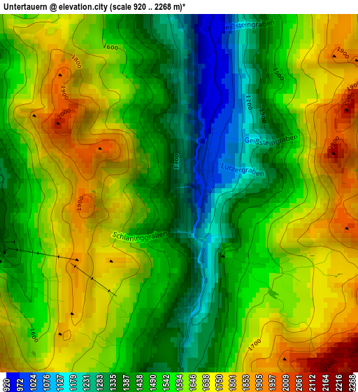
Below is the Elevation map of Untertauern, which displays elevation range with different colors. Scale of the first map is from 920 to 2268 m (3018 to 7441 ft) with average elevation of 1567 meters (=5141 ft) [note 1]
These maps also provides idea of topography and contour of this city, they are displayed at different zoom levels. More info about maps, scale and edge coordinates you can find below images.
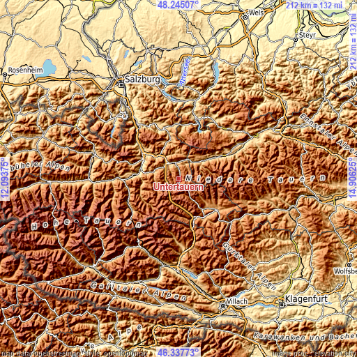
| \ | Map #1 | Topo.Map |
| Scale [m] | 920..2268 m | × |
| Scale [ft] | 3018..7441 ft | × |
| Average | 1567 m = 5141 ft | × |
| Width | 6.63 km = 4.1 mi | 212.1 km = 131.8 mi |
| Height | 6.63 km = 4.1 mi | 212.1 km = 131.8 mi |
| ↑Max Latitude | 47.329794° | 48.24507° |
| Latitude at center | 47.3° | 47.3° |
| ↓Min Latitude | 47.27019° | 46.33773° |
| ← Min Longitude | 13.456055° | 12.09375° |
| Longitude center | 13.5° | 13.5° |
| →Max Longitude | 13.543945° | 14.90625° |
Nearby cities:
Cities around Untertauern sort by population:
• Altenmarkt im Pongau elevation 841 m
11.2 km,  325°
325°
• Schladming 738 m
17.5 km,  53°
53°
• Radstadt 839 m
10 km,  337°
337°
• Eben im Pongau 849 m
13.4 km, 325°
• Hof 935 m
14.9 km,  291°
291°
• Flachau 907 m
9.5 km,  300°
300°
• Kleinarl 1001 m
13.8 km,  259°
259°
• Filzmoos 1051 m
14.9 km,  4°
4°
• Zederhaus 1230 m
16.1 km,  178°
178°
• Forstau 892 m
9.7 km,  25°
25°
• Wagrain 849 m
15.7 km,  284°
284°
• Tweng 1435 m
15 km,  149°
149°
Multilingual:
 En español:
Untertauern elevación 1166 m.
 En France:
Untertauern élévation 1166 m.
 Auf Deutsch:
Untertauern höhe über dem Meeresspiegel ist 1166 m.

Sources and notes:
- [note 1] Map square and city borders are not equal. Map elevation data is calculated only from area inside that square.
- [src 1] Elevation data from geonames database provided with same terms of usage.
- [src 2] The elevation map of Untertauern is generated using elevation data from NASA's 3 arcsec (90m) resolution SRTM data.
- [src 3] Base (background) map © OpenStreetMap contributors tiles are generated by Geofabrik and OpenTopoMap.
Copyright & License:
This Untertauern Elevation Map is licensed under CC BY-SA. You may reuse any part from this page, if you give a proper credit by linking to this URL:
 More info on terms of use page.