Zederhaus elevation
Zederhaus (Salzburg, Politischer Bezirk Tamsweg), Austria elevation is 1230 meters and Zederhaus elevation in feet is 4035 ft above sea level [src 1]. Zederhaus is a seat of a third-order administrative division (feature code) with elevation that is 721 meters (2365 ft) bigger than average city elevation in Austria.
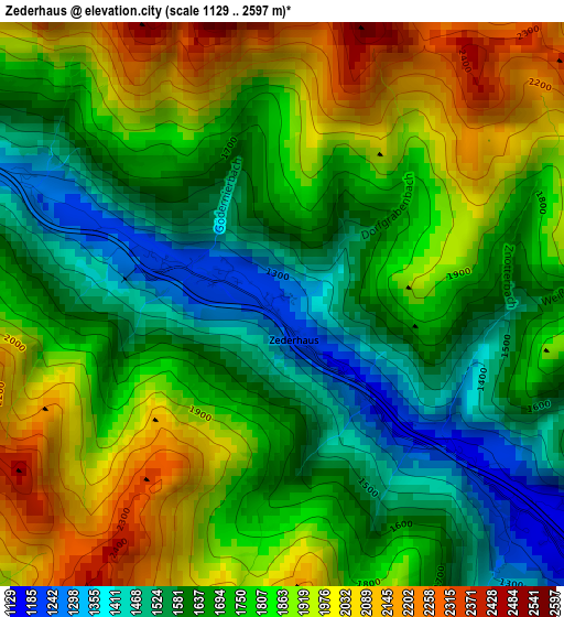
Below is the Elevation map of Zederhaus, which displays elevation range with different colors. Scale of the first map is from 1129 to 2597 m (3704 to 8520 ft) with average elevation of 1757 meters (=5764 ft) [note 1]
These maps also provides idea of topography and contour of this city, they are displayed at different zoom levels. More info about maps, scale and edge coordinates you can find below images.
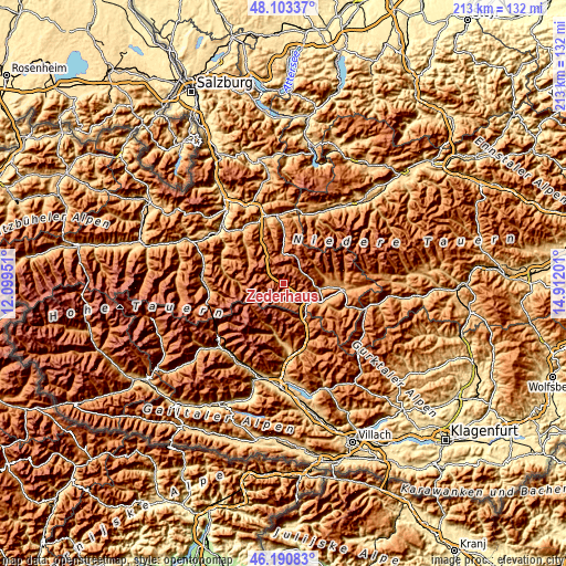
| \ | Map #1 | Topo.Map |
| Scale [m] | 1129..2597 m | × |
| Scale [ft] | 3704..8520 ft | × |
| Average | 1757 m = 5764 ft | × |
| Width | 6.65 km = 4.1 mi | 212.7 km = 132.2 mi |
| Height | 6.65 km = 4.1 mi | 212.6 km = 132.1 mi |
| ↑Max Latitude | 47.185575° | 48.10337° |
| Latitude at center | 47.1557° | 47.1557° |
| ↓Min Latitude | 47.125808° | 46.19083° |
| ← Min Longitude | 13.461815° | 12.09951° |
| Longitude center | 13.50576° | 13.50576° |
| →Max Longitude | 13.549705° | 14.91201° |
Nearby cities:
Cities around Zederhaus sort by population:
• Sankt Michael im Lungau elevation 1088 m
11.5 km,  122°
122°
• Mariapfarr 1115 m
18.5 km,  91°
91°
• Mauterndorf 1128 m
13.3 km,  100°
100°
• Unternberg 1022 m
18.5 km, 104°
• Kleinarl 1001 m
19.5 km,  313°
313°
• Sankt Andrä im Lungau 1129 m
21 km, 91°
• Sankt Margarethen im Lungau 1063 m
16.7 km, 120°
• Hüttschlag 974 m
20.8 km,  276°
276°
• Rennweg am Katschberg 1162 m
17.6 km,  151°
151°
• Tweng 1435 m
7.8 km,  66°
66°
• Untertauern 1166 m
16.1 km,  358°
358°
• Muhr 1113 m
6.3 km,  185°
185°
Multilingual:
 En español:
Zederhaus elevación 1230 m.
 En France:
Zederhaus élévation 1230 m.
 Auf Deutsch:
Zederhaus höhe über dem Meeresspiegel ist 1230 m.

Sources and notes:
- [note 1] Map square and city borders are not equal. Map elevation data is calculated only from area inside that square.
- [src 1] Elevation data from geonames database provided with same terms of usage.
- [src 2] The elevation map of Zederhaus is generated using elevation data from NASA's 3 arcsec (90m) resolution SRTM data.
- [src 3] Base (background) map © OpenStreetMap contributors tiles are generated by Geofabrik and OpenTopoMap.
Copyright & License:
This Zederhaus Elevation Map is licensed under CC BY-SA. You may reuse any part from this page, if you give a proper credit by linking to this URL:
 More info on terms of use page.