Völs elevation
Völs (Tyrol, Politischer Bezirk Innsbruck Land), Austria elevation is 605 meters and Völs elevation in feet is 1985 ft above sea level [src 1]. Völs is a seat of a third-order administrative division (feature code) with elevation that is 96 meters (315 ft) bigger than average city elevation in Austria.
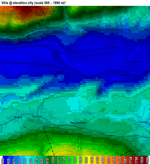
Below is the Elevation map of Völs, which displays elevation range with different colors. Scale of the first map is from 569 to 1890 m (1867 to 6201 ft) with average elevation of 822.7 meters (=2699 ft) [note 1]
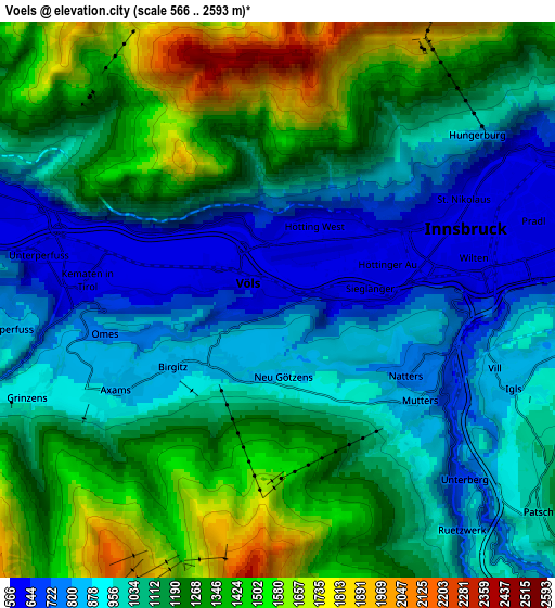
These maps also provides idea of topography and contour of this city, they are displayed at different zoom levels. More info about maps, scale and edge coordinates you can find below images.
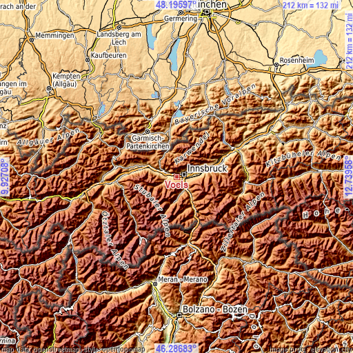
| \ | Map #1 | Map #2 | Topo.Map |
| Scale [m] | 569..1890 m | 566..2593 m | × |
| Scale [ft] | 1867..6201 ft | 1857..8507 ft | × |
| Average | 822.7 m = 2699 ft | 1115.5 m = 3660 ft | × |
| Width | 6.63 km = 4.1 mi | 13.27 km = 8.2 mi | 212.3 km = 131.9 mi |
| Height | 6.63 km = 4.1 mi | 13.27 km = 8.2 mi | 212.3 km = 131.9 mi |
| ↑Max Latitude | 47.279822° | 47.309627° | 48.19597° |
| Latitude at center | 47.25° | 47.25° | 47.25° |
| ↓Min Latitude | 47.220161° | 47.190306° | 46.28683° |
| ← Min Longitude | 11.289385° | 11.245439° | 9.92708° |
| Longitude center | 11.33333° | 11.33333° | 11.33333° |
| →Max Longitude | 11.377275° | 11.421221° | 12.73958° |
Nearby cities:
Cities around Völs sort by population:
• Innsbruck elevation 587 m
4.8 km,  73°
73°
• Hötting 636 m
3.3 km,  52°
52°
• Wilten 588 m
4.2 km,  77°
77°
• Amras 781 m
6.3 km,  90°
90°
• Mühlau 698 m
6.2 km, 53°
• Axams 876 m
4.6 km,  242°
242°
• Götzens 868 m
2.3 km,  226°
226°
• Kematen in Tirol 630 m
5 km,  270°
270°
• Igls 940 m
6.2 km,  109°
109°
• Natters 779 m
3.5 km,  120°
120°
• Mutters 776 m
4.2 km, 116°
• Birgitz 859 m
3 km, 237°
Multilingual:
 En español:
Völs elevación 605 m.
 En France:
Völs élévation 605 m.


Sources and notes:
- [note 1] Map square and city borders are not equal. Map elevation data is calculated only from area inside that square.
- [src 1] Elevation data from geonames database provided with same terms of usage.
- [src 2] The elevation map of Völs is generated using elevation data from NASA's 3 arcsec (90m) resolution SRTM data.
- [src 3] Base (background) map © OpenStreetMap contributors tiles are generated by Geofabrik and OpenTopoMap.
Copyright & License:
This Völs Elevation Map is licensed under CC BY-SA. You may reuse any part from this page, if you give a proper credit by linking to this URL:
 More info on terms of use page.