Capayán elevation
Capayán (Catamarca, Departamento de Capayán), Argentina elevation is 445 meters and Capayán elevation in feet is 1460 ft above sea level [src 1]. Capayán is a populated place (feature code) with elevation that is 95 meters (312 ft) bigger than average city elevation in Argentina.
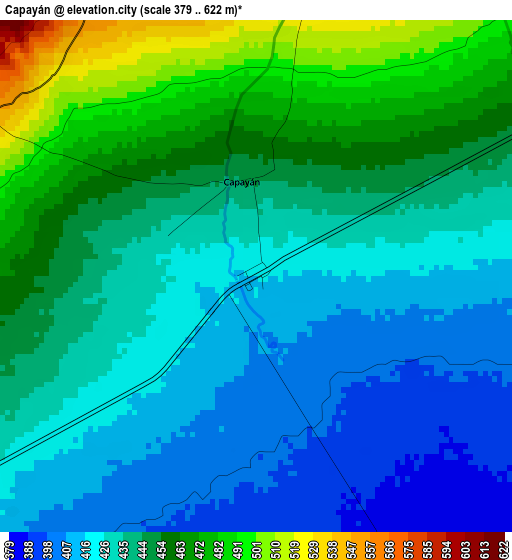
Below is the Elevation map of Capayán, which displays elevation range with different colors. Scale of the first map is from 379 to 622 m (1243 to 2041 ft) with average elevation of 439.5 meters (=1442 ft) [note 1]
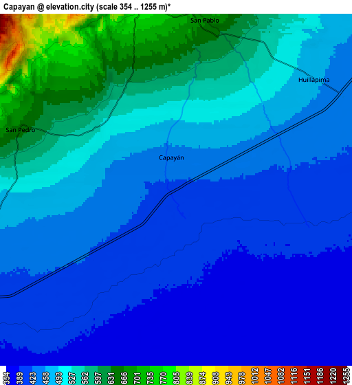
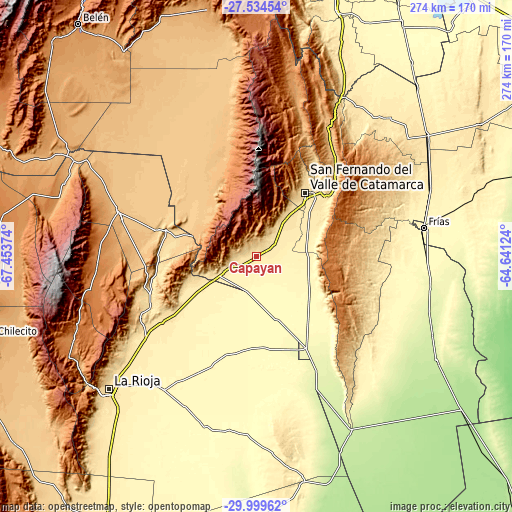
These maps also provides idea of topography and contour of this city, they are displayed at different zoom levels. More info about maps, scale and edge coordinates you can find below images.
| \ | Map #1 | Map #2 | Topo.Map |
| Scale [m] | 379..622 m | 354..1255 m | × |
| Scale [ft] | 1243..2041 ft | 1161..4117 ft | × |
| Average | 439.5 m = 1442 ft | 480.9 m = 1578 ft | × |
| Width | 8.57 km = 5.3 mi | 17.13 km = 10.6 mi | 274.1 km = 170.3 mi |
| Height | 8.57 km = 5.3 mi | 17.13 km = 10.6 mi | 274.1 km = 170.3 mi |
| ↑Max Latitude | -28.735834° | -28.697293° | -27.53454° |
| Latitude at center | -28.77436° | -28.77436° | -28.77436° |
| ↓Min Latitude | -28.812872° | -28.85137° | -29.99962° |
| ← Min Longitude | -66.091435° | -66.135381° | -67.45374° |
| Longitude center | -66.04749° | -66.04749° | -66.04749° |
| →Max Longitude | -66.003545° | -65.959599° | -64.64124° |
Nearby cities:
Cities around Capayán sort by population:
• San Fernando del Valle de Catamarca elevation 545 m
42.5 km,  37°
37°
• Huillapima 467 m
8.6 km,  50°
50°
• Icaño 358 m
71.9 km,  102°
102°
• Pomán 1167 m
45.5 km,  338°
338°
• Ancasti 883 m
53.4 km,  94°
94°
• Mutquín 1681 m
51.3 km,  349°
349°
• El Rodeo 1296 m
64.4 km,  15°
15°
• La Puerta 892 m
71.7 km, 20°
• Saujil 895 m
68.6 km, 346°
• San José 584 m
55.2 km, 37°
• San Isidro 518 m
46.8 km, 42°
• Chumbicha 427 m
20.3 km,  244°
244°
Multilingual:
 En español:
Capayán elevación 445 m.
 En France:
Capayán élévation 445 m.


Sources and notes:
- [note 1] Map square and city borders are not equal. Map elevation data is calculated only from area inside that square.
- [src 1] Elevation data from geonames database provided with same terms of usage.
- [src 2] The elevation map of Capayán is generated using elevation data from NASA's 3 arcsec (90m) resolution SRTM data.
- [src 3] Base (background) map © OpenStreetMap contributors tiles are generated by Geofabrik and OpenTopoMap.
Copyright & License:
This Capayán Elevation Map is licensed under CC BY-SA. You may reuse any part from this page, if you give a proper credit by linking to this URL:
 More info on terms of use page.