Chumbicha elevation
Chumbicha (Catamarca, Departamento de Capayán), Argentina elevation is 427 meters and Chumbicha elevation in feet is 1401 ft above sea level [src 1]. Chumbicha is a seat of a second-order administrative division (feature code) with elevation that is 77 meters (253 ft) bigger than average city elevation in Argentina.
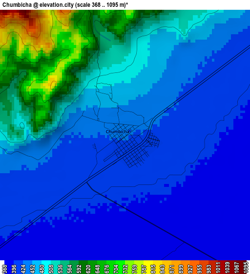
Below is the Elevation map of Chumbicha, which displays elevation range with different colors. Scale of the first map is from 368 to 1095 m (1207 to 3593 ft) with average elevation of 466.3 meters (=1530 ft) [note 1]
These maps also provides idea of topography and contour of this city, they are displayed at different zoom levels. More info about maps, scale and edge coordinates you can find below images.
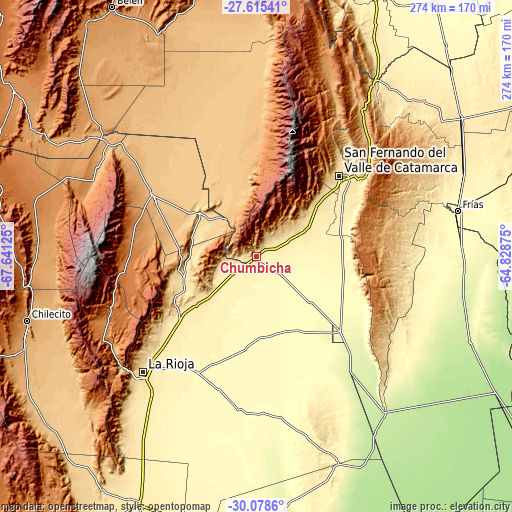
| \ | Map #1 | Topo.Map |
| Scale [m] | 368..1095 m | × |
| Scale [ft] | 1207..3593 ft | × |
| Average | 466.3 m = 1530 ft | × |
| Width | 8.56 km = 5.3 mi | 273.9 km = 170.2 mi |
| Height | 8.56 km = 5.3 mi | 273.9 km = 170.2 mi |
| ↑Max Latitude | -28.815803° | -27.61541° |
| Latitude at center | -28.8543° | -28.8543° |
| ↓Min Latitude | -28.892782° | -30.0786° |
| ← Min Longitude | -66.278945° | -67.64125° |
| Longitude center | -66.235° | -66.235° |
| →Max Longitude | -66.191055° | -64.82875° |
Nearby cities:
Cities around Chumbicha sort by population:
• San Fernando del Valle de Catamarca elevation 545 m
61.3 km,  45°
45°
• Arauco 820 m
62.3 km,  299°
299°
• Huillapima 467 m
28.8 km,  60°
60°
• Capayán 445 m
20.3 km, 64°
• Pomán 1167 m
51.1 km,  1°
1°
• Ancasti 883 m
71.6 km,  86°
86°
• Mutquín 1681 m
60 km,  8°
8°
• Saujil 895 m
75.6 km, 1°
• San José 584 m
74 km,  44°
44°
• Aminga 1388 m
67.7 km,  270°
270°
• San Isidro 518 m
66.1 km, 48°
• Aimogasta 846 m
64.5 km, 300°
Multilingual:
 En español:
Chumbicha elevación 427 m.
 En France:
Chumbicha élévation 427 m.
 Auf Deutsch:
Chumbicha höhe über dem Meeresspiegel ist 427 m.

Sources and notes:
- [note 1] Map square and city borders are not equal. Map elevation data is calculated only from area inside that square.
- [src 1] Elevation data from geonames database provided with same terms of usage.
- [src 2] The elevation map of Chumbicha is generated using elevation data from NASA's 3 arcsec (90m) resolution SRTM data.
- [src 3] Base (background) map © OpenStreetMap contributors tiles are generated by Geofabrik and OpenTopoMap.
Copyright & License:
This Chumbicha Elevation Map is licensed under CC BY-SA. You may reuse any part from this page, if you give a proper credit by linking to this URL:
 More info on terms of use page.