Ceres elevation
Ceres (Santa Fe, Departamento de San Cristóbal), Argentina elevation is 90 meters and Ceres elevation in feet is 295 ft above sea level [src 1]. Ceres is a populated place (feature code) with elevation that is 260 meters (853 ft) smaller than average city elevation in Argentina.
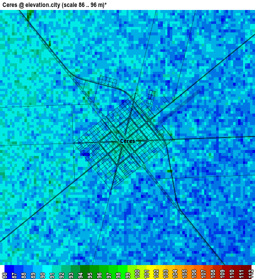
Below is the Elevation map of Ceres, which displays elevation range with different colors. Scale of the first map is from 86 to 96 m (282 to 315 ft) with average elevation of 89.1 meters (=292 ft) [note 1]
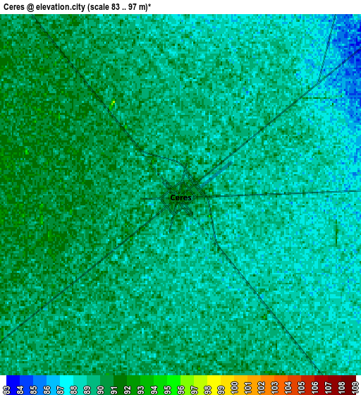
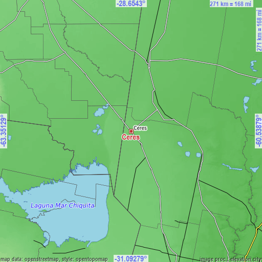
These maps also provides idea of topography and contour of this city, they are displayed at different zoom levels. More info about maps, scale and edge coordinates you can find below images.
| \ | Map #1 | Map #2 | Topo.Map |
| Scale [m] | 86..96 m | 83..97 m | × |
| Scale [ft] | 282..315 ft | 272..318 ft | × |
| Average | 89.1 m = 292 ft | 88.9 m = 292 ft | × |
| Width | 8.47 km = 5.3 mi | 16.95 km = 10.5 mi | 271.1 km = 168.5 mi |
| Height | 8.47 km = 5.3 mi | 16.95 km = 10.5 mi | 271.1 km = 168.5 mi |
| ↑Max Latitude | -29.842889° | -29.804764° | -28.6543° |
| Latitude at center | -29.881° | -29.881° | -29.881° |
| ↓Min Latitude | -29.919096° | -29.957177° | -31.09279° |
| ← Min Longitude | -61.988985° | -62.032931° | -63.35129° |
| Longitude center | -61.94504° | -61.94504° | -61.94504° |
| →Max Longitude | -61.901095° | -61.857149° | -60.53879° |
Nearby cities:
Cities around Ceres sort by population:
• Sunchales elevation 98 m
123.8 km,  162°
162°
• Morteros 99 m
92.5 km,  183°
183°
• San Cristóbal 79 m
83.2 km,  125°
125°
• Tostado 77 m
74.1 km,  13°
13°
• Brinkmann 105 m
109.9 km, 184°
• Villa General Mitre 90 m
106.9 km,  320°
320°
• Hersilia 93 m
17 km,  143°
143°
• Villa Trinidad 95 m
37.5 km,  169°
169°
• Arrufó 94 m
44.3 km,  151°
151°
• Bandera 97 m
114.7 km,  344°
344°
• Villa Unión 87 m
96.6 km,  302°
302°
• Selva 88 m
16 km, 321°
Multilingual:
 En español:
Ceres elevación 90 m.
 En France:
Ceres élévation 90 m.


Sources and notes:
- [note 1] Map square and city borders are not equal. Map elevation data is calculated only from area inside that square.
- [src 1] Elevation data from geonames database provided with same terms of usage.
- [src 2] The elevation map of Ceres is generated using elevation data from NASA's 3 arcsec (90m) resolution SRTM data.
- [src 3] Base (background) map © OpenStreetMap contributors tiles are generated by Geofabrik and OpenTopoMap.
Copyright & License:
This Ceres Elevation Map is licensed under CC BY-SA. You may reuse any part from this page, if you give a proper credit by linking to this URL:
 More info on terms of use page.