Crespo elevation
Crespo (Entre Rios, Departamento de Paraná), Argentina elevation is 109 meters and Crespo elevation in feet is 358 ft above sea level [src 1]. Crespo is a populated place (feature code) with elevation that is 241 meters (791 ft) smaller than average city elevation in Argentina.
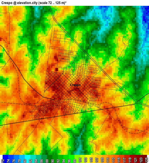
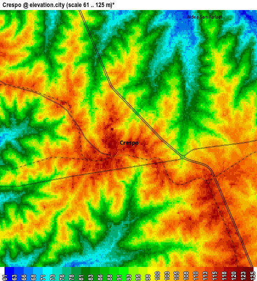
Below is the Elevation map of Crespo, which displays elevation range with different colors. Scale of the first map is from 72 to 125 m (236 to 410 ft) with average elevation of 102.3 meters (=336 ft) [note 1]
These maps also provides idea of topography and contour of this city, they are displayed at different zoom levels. More info about maps, scale and edge coordinates you can find below images.
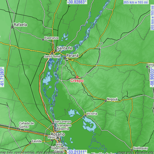
| \ | Map #1 | Map #2 | Topo.Map |
| Scale [m] | 72..125 m | 61..125 m | × |
| Scale [ft] | 236..410 ft | 200..410 ft | × |
| Average | 102.3 m = 336 ft | 95.4 m = 313 ft | × |
| Width | 8.28 km = 5.1 mi | 16.57 km = 10.3 mi | 265.1 km = 164.7 mi |
| Height | 8.28 km = 5.1 mi | 16.57 km = 10.3 mi | 265.1 km = 164.7 mi |
| ↑Max Latitude | -31.991466° | -31.954188° | -30.82883° |
| Latitude at center | -32.02873° | -32.02873° | -32.02873° |
| ↓Min Latitude | -32.065978° | -32.103212° | -33.21311° |
| ← Min Longitude | -60.350525° | -60.394471° | -61.71283° |
| Longitude center | -60.30658° | -60.30658° | -60.30658° |
| →Max Longitude | -60.262635° | -60.218689° | -58.90033° |
Nearby cities:
Cities around Crespo sort by population:
• Paraná elevation 68 m
39 km,  327°
327°
• Diamante 71 m
31.5 km,  262°
262°
• Viale 71 m
33.4 km,  57°
57°
• General Ramírez 117 m
19.2 km,  148°
148°
• Villa María Grande 94 m
55.6 km,  43°
43°
• San Benito 61 m
30.1 km, 334°
• Seguí 102 m
18.9 km, 64°
• Oro Verde 86 m
30.1 km,  318°
318°
• Hernández 100 m
43.5 km,  141°
141°
• Aranguren 114 m
27.4 km, 150°
• Villa Urquiza 51 m
42.9 km,  351°
351°
• Tabossi 100 m
43.3 km,  54°
54°
Multilingual:
 En español:
Crespo elevación 109 m.
 En France:
Crespo élévation 109 m.


Sources and notes:
- [note 1] Map square and city borders are not equal. Map elevation data is calculated only from area inside that square.
- [src 1] Elevation data from geonames database provided with same terms of usage.
- [src 2] The elevation map of Crespo is generated using elevation data from NASA's 3 arcsec (90m) resolution SRTM data.
- [src 3] Base (background) map © OpenStreetMap contributors tiles are generated by Geofabrik and OpenTopoMap.
Copyright & License:
This Crespo Elevation Map is licensed under CC BY-SA. You may reuse any part from this page, if you give a proper credit by linking to this URL:
 More info on terms of use page.