Paraná elevation
Paraná (Entre Rios, Departamento de Paraná), Argentina elevation is 68 meters and Paraná elevation in feet is 223 ft above sea level [src 1]. Paraná is a seat of a first-order administrative division (feature code) with elevation that is 282 meters (925 ft) smaller than average city elevation in Argentina.
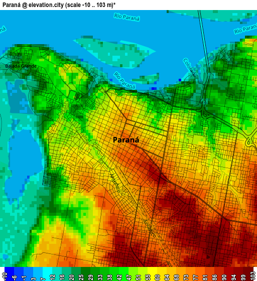
Below is the Elevation map of Paraná, which displays elevation range with different colors. Scale of the first map is from -10 to 103 m (-33 to 338 ft) with average elevation of 44.2 meters (=145 ft) [note 1]
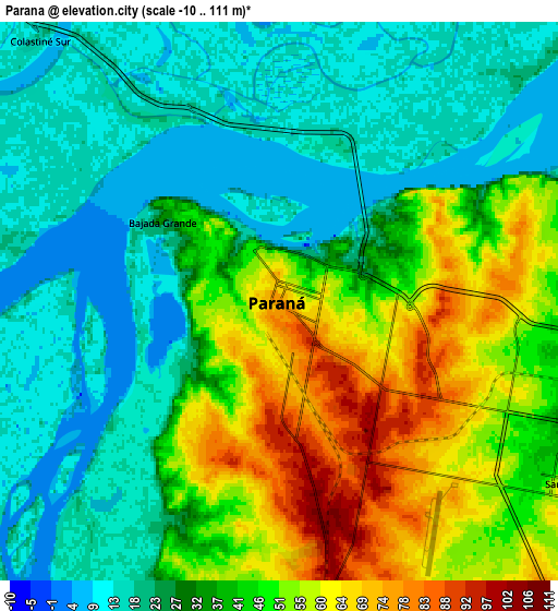
These maps also provides idea of topography and contour of this city, they are displayed at different zoom levels. More info about maps, scale and edge coordinates you can find below images.
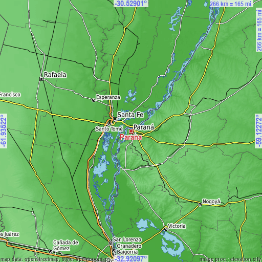
| \ | Map #1 | Map #2 | Topo.Map |
| Scale [m] | -10..103 m | -10..111 m | × |
| Scale [ft] | -33..338 ft | -33..364 ft | × |
| Average | 44.2 m = 145 ft | 36.4 m = 119 ft | × |
| Width | 8.31 km = 5.2 mi | 16.62 km = 10.3 mi | 266 km = 165.3 mi |
| Height | 8.31 km = 5.2 mi | 16.62 km = 10.3 mi | 266 km = 165.3 mi |
| ↑Max Latitude | -31.695326° | -31.657928° | -30.52901° |
| Latitude at center | -31.73271° | -31.73271° | -31.73271° |
| ↓Min Latitude | -31.770078° | -31.807432° | -32.92097° |
| ← Min Longitude | -60.572915° | -60.616861° | -61.93522° |
| Longitude center | -60.52897° | -60.52897° | -60.52897° |
| →Max Longitude | -60.485025° | -60.441079° | -59.12272° |
Nearby cities:
Cities around Paraná sort by population:
• Santa Fe elevation 20 m
19.4 km,  298°
298°
• Santo Tomé 19 m
23.7 km,  289°
289°
• Esperanza 40 m
49.5 km,  309°
309°
• Diamante 71 m
38.5 km,  195°
195°
• Crespo 109 m
39 km,  147°
147°
• Coronda 19 m
45.5 km,  234°
234°
• Recreo 23 m
33.1 km,  324°
324°
• Laguna Paiva 24 m
49.2 km,  345°
345°
• San Benito 61 m
10 km,  124°
124°
• Seguí 102 m
45.6 km, 123°
• Oro Verde 86 m
10.3 km,  173°
173°
• Villa Urquiza 51 m
17.4 km,  56°
56°
Multilingual:
 En español:
Paraná elevación 68 m.
 En France:
Paraná élévation 68 m.


Sources and notes:
- [note 1] Map square and city borders are not equal. Map elevation data is calculated only from area inside that square.
- [src 1] Elevation data from geonames database provided with same terms of usage.
- [src 2] The elevation map of Paraná is generated using elevation data from NASA's 3 arcsec (90m) resolution SRTM data.
- [src 3] Base (background) map © OpenStreetMap contributors tiles are generated by Geofabrik and OpenTopoMap.
Copyright & License:
This Paraná Elevation Map is licensed under CC BY-SA. You may reuse any part from this page, if you give a proper credit by linking to this URL:
 More info on terms of use page.