Malagueño elevation
Malagueño (Cordoba, Departamento de Santa María), Argentina elevation is 568 meters and Malagueño elevation in feet is 1864 ft above sea level [src 1]. Malagueño is a populated place (feature code) with elevation that is 218 meters (715 ft) bigger than average city elevation in Argentina.
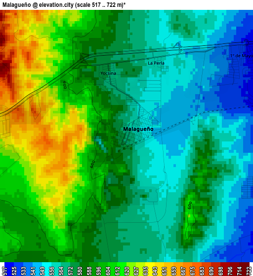
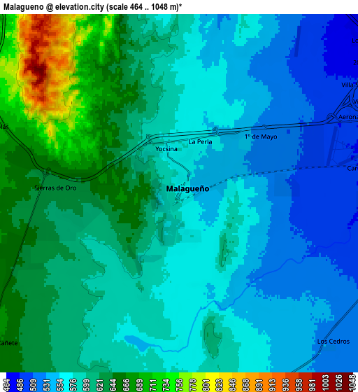
Below is the Elevation map of Malagueño, which displays elevation range with different colors. Scale of the first map is from 517 to 722 m (1696 to 2369 ft) with average elevation of 585.1 meters (=1920 ft) [note 1]
These maps also provides idea of topography and contour of this city, they are displayed at different zoom levels. More info about maps, scale and edge coordinates you can find below images.
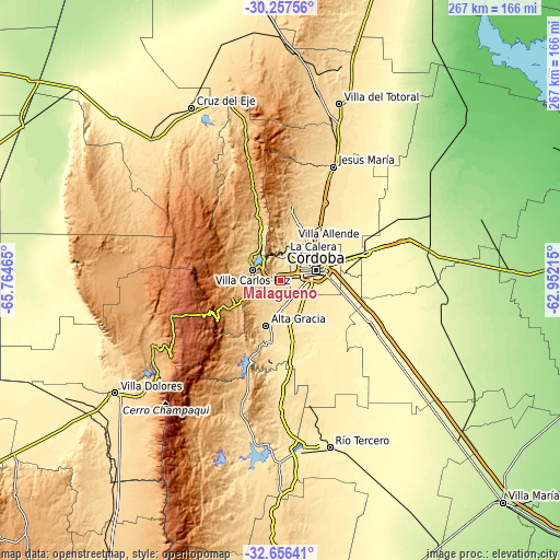
| \ | Map #1 | Map #2 | Topo.Map |
| Scale [m] | 517..722 m | 464..1048 m | × |
| Scale [ft] | 1696..2369 ft | 1522..3438 ft | × |
| Average | 585.1 m = 1920 ft | 594.8 m = 1951 ft | × |
| Width | 8.34 km = 5.2 mi | 16.67 km = 10.4 mi | 266.7 km = 165.7 mi |
| Height | 8.34 km = 5.2 mi | 16.67 km = 10.4 mi | 266.7 km = 165.7 mi |
| ↑Max Latitude | -31.427179° | -31.389673° | -30.25756° |
| Latitude at center | -31.46467° | -31.46467° | -31.46467° |
| ↓Min Latitude | -31.502146° | -31.539607° | -32.65641° |
| ← Min Longitude | -64.402345° | -64.446291° | -65.76465° |
| Longitude center | -64.3584° | -64.3584° | -64.3584° |
| →Max Longitude | -64.314455° | -64.270509° | -62.95215° |
Nearby cities:
Cities around Malagueño sort by population:
• Córdoba elevation 395 m
17.8 km,  71°
71°
• Villa Carlos Paz 666 m
14 km,  288°
288°
• Alta Gracia 556 m
22 km,  197°
197°
• La Calera 495 m
13.6 km,  9°
9°
• Villa Allende 505 m
19.8 km,  17°
17°
• Cosquín 707 m
26.5 km,  337°
337°
• Río Ceballos 705 m
33.5 km, 5°
• Unquillo 633 m
26.3 km, 8°
• Malvinas Argentinas 397 m
30.2 km, 72°
• Mendiolaza 540 m
22.6 km, 13°
• Cuesta Blanca 756 m
20.4 km,  263°
263°
• Saldán 495 m
18.7 km, 15°
Multilingual:
 En español:
Malagueño elevación 568 m.
 En France:
Malagueño élévation 568 m.
 Auf Deutsch:
Malagueño höhe über dem Meeresspiegel ist 568 m.

Sources and notes:
- [note 1] Map square and city borders are not equal. Map elevation data is calculated only from area inside that square.
- [src 1] Elevation data from geonames database provided with same terms of usage.
- [src 2] The elevation map of Malagueño is generated using elevation data from NASA's 3 arcsec (90m) resolution SRTM data.
- [src 3] Base (background) map © OpenStreetMap contributors tiles are generated by Geofabrik and OpenTopoMap.
Copyright & License:
This Malagueño Elevation Map is licensed under CC BY-SA. You may reuse any part from this page, if you give a proper credit by linking to this URL:
 More info on terms of use page.