Mina Clavero elevation
Mina Clavero (Cordoba, Departamento de San Alberto), Argentina elevation is 895 meters and Mina Clavero elevation in feet is 2936 ft above sea level [src 1]. Mina Clavero is a populated place (feature code) with elevation that is 545 meters (1788 ft) bigger than average city elevation in Argentina.
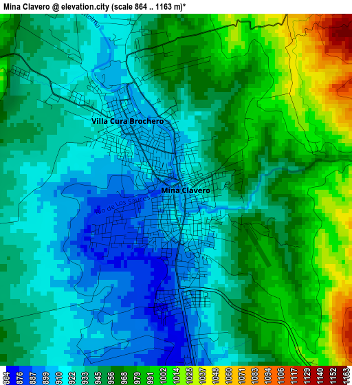
Below is the Elevation map of Mina Clavero, which displays elevation range with different colors. Scale of the first map is from 864 to 1163 m (2835 to 3816 ft) with average elevation of 948.1 meters (=3111 ft) [note 1]
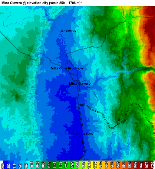
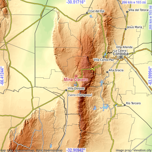
These maps also provides idea of topography and contour of this city, they are displayed at different zoom levels. More info about maps, scale and edge coordinates you can find below images.
| \ | Map #1 | Map #2 | Topo.Map |
| Scale [m] | 864..1163 m | 850..1706 m | × |
| Scale [ft] | 2835..3816 ft | 2789..5597 ft | × |
| Average | 948.1 m = 3111 ft | 1042 m = 3419 ft | × |
| Width | 8.31 km = 5.2 mi | 16.63 km = 10.3 mi | 266 km = 165.3 mi |
| Height | 8.31 km = 5.2 mi | 16.63 km = 10.3 mi | 266 km = 165.3 mi |
| ↑Max Latitude | -31.683622° | -31.646218° | -30.51716° |
| Latitude at center | -31.72101° | -31.72101° | -31.72101° |
| ↓Min Latitude | -31.758383° | -31.795741° | -32.90942° |
| ← Min Longitude | -65.050135° | -65.094081° | -66.41244° |
| Longitude center | -65.00619° | -65.00619° | -65.00619° |
| →Max Longitude | -64.962245° | -64.918299° | -63.59994° |
Nearby cities:
Cities around Mina Clavero sort by population:
• Villa Carlos Paz elevation 666 m
58.4 km,  55°
55°
• Alta Gracia 556 m
55.2 km,  82°
82°
• Villa Dolores 523 m
30.4 km,  214°
214°
• Santa Rosa de Calamuchita 598 m
58.9 km,  131°
131°
• Villa General Belgrano 742 m
51.2 km,  123°
123°
• Villa Berna 1373 m
33.6 km, 129°
• Villa Cura Brochero 909 m
2 km,  326°
326°
• Cuesta Blanca 756 m
48.7 km, 57°
• San Agustín 548 m
66.1 km, 115°
• Villa Las Rosas 744 m
25.9 km,  189°
189°
• San Carlos 756 m
61.1 km,  351°
351°
• Salsacate 927 m
45.5 km, 349°
Multilingual:
 En español:
Mina Clavero elevación 895 m.
 En France:
Mina Clavero élévation 895 m.
 Auf Deutsch:
Mina Clavero höhe über dem Meeresspiegel ist 895 m.

Sources and notes:
- [note 1] Map square and city borders are not equal. Map elevation data is calculated only from area inside that square.
- [src 1] Elevation data from geonames database provided with same terms of usage.
- [src 2] The elevation map of Mina Clavero is generated using elevation data from NASA's 3 arcsec (90m) resolution SRTM data.
- [src 3] Base (background) map © OpenStreetMap contributors tiles are generated by Geofabrik and OpenTopoMap.
Copyright & License:
This Mina Clavero Elevation Map is licensed under CC BY-SA. You may reuse any part from this page, if you give a proper credit by linking to this URL:
 More info on terms of use page.